IMAGES TAKEN NEAR TO
Arkenley Lane, HUDDERSFIELD, HD4 6SQ
Introduction
This page details the photographs taken nearby to Arkenley Lane, HD4 6SQ by members of the Geograph project.
The Geograph project started in 2005 with the aim of publishing, organising and preserving representative images for every square kilometre of Great Britain, Ireland and the Isle of Man.

There are currently over 7.5m images from over14,400 individuals and you can help contribute to the project by visiting https://www.geograph.org.uk
Image Map
Images are licensed for reuse under creativecommons.org/licenses/by-sa/2.0
Notes
- Clicking on the map will re-center to the selected point.
- The higher the marker number, the further away the image location is from the centre of the postcode.
Image Listing (7 Images Found)
Images are licensed for reuse under creativecommons.org/licenses/by-sa/2.0
Image
Details
Distance
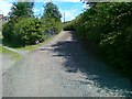
1
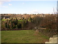
Rusfield Dike valley, Farnley Tyas, Yorkshire
The far side of the valley is in Almondbury, and the church can be seen on the horizon. The road is St Helen's Road.
Image: © Humphrey Bolton
Taken: 9 Feb 2006
0.13 miles
2
Almondbury Common.
Just a small piece left of the original Common Land.
Image: © Stanley Walker
Taken: 14 Mar 2007
0.18 miles
3
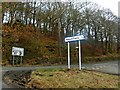
Road junction near Almondbury, Huddersfield
Image: © Steve Fareham
Taken: 21 Feb 2009
0.21 miles
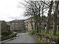
4
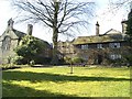
Almondbury Grammar School
The school's origins go back to 1547,and in 1608 the school received its Royal Charter and became known as King James Free Grammar School and up till recent times was a boys' only school. It is now mixed.
Image: © Stanley Walker
Taken: 14 Mar 2007
0.21 miles
6
Northfield Mills, Almondbury Common
'Fancy woollen' manufacture, according to Old Maps. Castle Hill in the background
Image: © John Slater
Taken: 9 Apr 2014
0.22 miles
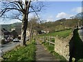
7
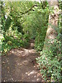
Woodland path near St James's School, Almondbury.
On the public footpath through a patch of woodland to the north of St James's. The path leads from St Helen's Gate to Grasscroft.
Image: © Samantha Waddington
Taken: 18 Sep 2011
0.24 miles