IMAGES TAKEN NEAR TO
Stoney Lane, HUDDERSFIELD, HD4 6HP
Introduction
This page details the photographs taken nearby to Stoney Lane, HD4 6HP by members of the Geograph project.
The Geograph project started in 2005 with the aim of publishing, organising and preserving representative images for every square kilometre of Great Britain, Ireland and the Isle of Man.

There are currently over 7.5m images from over14,400 individuals and you can help contribute to the project by visiting https://www.geograph.org.uk
Image Map
Images are licensed for reuse under creativecommons.org/licenses/by-sa/2.0
Notes
- Clicking on the map will re-center to the selected point.
- The higher the marker number, the further away the image location is from the centre of the postcode.
Image Listing (102 Images Found)
Images are licensed for reuse under creativecommons.org/licenses/by-sa/2.0
Image
Details
Distance
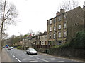
1
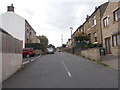
Back Stoney Lane - Stoney Cross Street
Image: © Betty Longbottom
Taken: 25 Jul 2016
0.03 miles
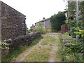
4
Stoney Cross Street - Taylor Hill Road
Image: © Betty Longbottom
Taken: 25 Jul 2016
0.05 miles
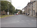
5
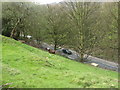
Down the hillside to Woodhead Road
Looking down from Taylor Hill Road, with a very puzzled goat watching every move I made.
Image: © Stephen Armstrong
Taken: 23 Apr 2010
0.07 miles
6
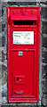
Victorian postbox on Taylor Hill Road
Postbox No. HD4 93.
Image: © JThomas
Taken: 15 Nov 2018
0.07 miles
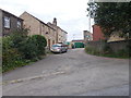
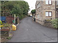
9
Fair Lea Road - viewed from Bankfield Park Avenue
Image: © Betty Longbottom
Taken: 25 Jul 2016
0.07 miles