IMAGES TAKEN NEAR TO
Taylor Hill Road, HUDDERSFIELD, HD4 6HH
Introduction
This page details the photographs taken nearby to Taylor Hill Road, HD4 6HH by members of the Geograph project.
The Geograph project started in 2005 with the aim of publishing, organising and preserving representative images for every square kilometre of Great Britain, Ireland and the Isle of Man.

There are currently over 7.5m images from over14,400 individuals and you can help contribute to the project by visiting https://www.geograph.org.uk
Image Map
Images are licensed for reuse under creativecommons.org/licenses/by-sa/2.0
Notes
- Clicking on the map will re-center to the selected point.
- The higher the marker number, the further away the image location is from the centre of the postcode.
Image Listing (70 Images Found)
Images are licensed for reuse under creativecommons.org/licenses/by-sa/2.0
Image
Details
Distance
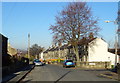
1
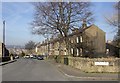
Taylor Hill Road, Taylor Hill, Almondbury
Looking towards Huddersfield from Fair Lea Avenue. Taylor Hill Road was part of the original main road up the Holme Valley, before the turnpike road was built to bypass the hill.
Image: © Humphrey Bolton
Taken: 5 Apr 2007
0.02 miles
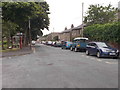
2
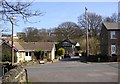
Fair Lea Avenue, Taylor Hill, Almondbury
Beyond the crossroads with Fair Lea Road there was a narrow lane leading to a pump. By 1906 the pair of houses with the mock half-timbering had been built, but not the terrace house on the right.
Image: © Humphrey Bolton
Taken: 5 Apr 2007
0.02 miles
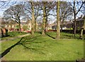
3
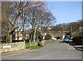
Fair Lea Avenue, Taylor Hill, Almondbury
Despite its name, this short road existed as a lane in 1850. The entrance on the left is to a small park.
Image: © Humphrey Bolton
Taken: 5 Apr 2007
0.02 miles
5
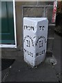
Old Milestone by No. 14, Fair Lea Road, Taylor Hill, Huddersfield
Carved stone post in garden, in parish of HUDDERSFIELD (KIRKLEES District), by No. 14, Fair Lea Road, Taylor Hill, now beside the front door (rhs), against the wall of the house. Hudds 'To - From' stone erected by an unknown authority in the 19th century.
Inscription reads:-
: FROM / HUDDERSFIELD / 1½ / MILES : : TO / HUDDERSFIELD / 1½ / MILES :
Listed: https://archaeologydataservice.ac.uk/archsearch/record?titleId=3393758
Milestone Society National ID: YW_XHTF28.
Image: © C Minto
Taken: 3 Feb 2012
0.03 miles
8
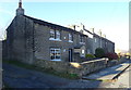
Park, Fair Lea Road, Taylor Hill, Almondbury
A wooded area in 1906, it has escaped development.
Image: © Humphrey Bolton
Taken: 5 Apr 2007
0.05 miles
9
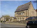
Former chapel, Taylor Hill Road, Taylor Hill, Almondbury
An unusual set of windows.
Image: © Humphrey Bolton
Taken: 5 Apr 2007
0.05 miles
10
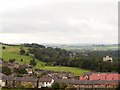
Newsome High School
View from the school playing fields, Honley in the middle distance
Image: © Stanley Walker
Taken: 12 Sep 2006
0.07 miles