IMAGES TAKEN NEAR TO
Woodhead Road, HUDDERSFIELD, HD4 6EP
Introduction
This page details the photographs taken nearby to Woodhead Road, HD4 6EP by members of the Geograph project.
The Geograph project started in 2005 with the aim of publishing, organising and preserving representative images for every square kilometre of Great Britain, Ireland and the Isle of Man.

There are currently over 7.5m images from over14,400 individuals and you can help contribute to the project by visiting https://www.geograph.org.uk
Image Map
Images are licensed for reuse under creativecommons.org/licenses/by-sa/2.0
Notes
- Clicking on the map will re-center to the selected point.
- The higher the marker number, the further away the image location is from the centre of the postcode.
Image Listing (218 Images Found)
Images are licensed for reuse under creativecommons.org/licenses/by-sa/2.0
Image
Details
Distance
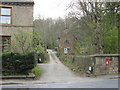
2
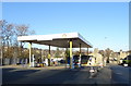
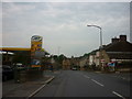
Service station on Woodhead Road, Huddersfield
Image: © JThomas
Taken: 15 Nov 2018
0.02 miles
3
Redeveloped factory site, Lockwood
These modern office buildings are on the site of a woollen mill. The tall building on the left is a row of shops fronting onto Bridge Street. The hillside above is Lockwood Scar, and a mill building looks as if it is being renovated. Above is the clock tower of Newsome Mills.
Image: © Humphrey Bolton
Taken: 11 Nov 2005
0.02 miles
4
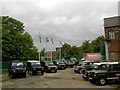
Land Rover Centre Lockwood
All sorts of Land Rovers here from coastguard version to campers.
Image: © Steve Fareham
Taken: 28 Jun 2008
0.03 miles
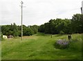
5
Solid, Woodhead Road
More like a track than a street, with a very strange name.
Image: © Stephen Armstrong
Taken: 23 Apr 2010
0.04 miles
6
A narrow cobbled road at Laith Croft, off Woodhead Road
The 1906 1:2500 map shows that this once led to a row of three houses. It now leads to a parking area behind 20C terrace houses on Woodhead Road, although I think there is a better vehicle access from Woodhead Road. The houses were shown on the six-inch map of c.1850, and were demolished c. 1965, possibly because the retaining wall holding up the land to the rear was collapsing. This part of Woodhead Road was called Salford Road in 1906.
Image: © Humphrey Bolton
Taken: 15 Jun 2006
0.04 miles
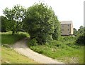
7
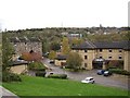
Green at Laith Croft, Salford, Almondbury
There were at one time many small cottages in this area. Now a footpath goes up a broad expanse of grass. It was only when I looked at the photo at home that I noticed the weather vane on top of the pole. I presume that this is the green maintained by the 'Lockwood and Salford village Green Committee (as seen on the Kirklees council website). If so, they are doing a good job!
Image: © Humphrey Bolton
Taken: 15 Jun 2006
0.04 miles
8
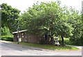
Police Station, Lockwood Scar, Salford, Almondbury
For sale? Actually there is a similar 'for sale' board half-way up Jacob's Row and no doubt the two are both for the same house.
Image: © Humphrey Bolton
Taken: 15 Jun 2006
0.04 miles
9
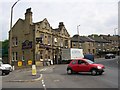
The Lockwood, Salford Road, Almondbury
Not the Salford near Manchester; the name is of the ford that was at the foot of Lockwood Scar before the bridge was built.
Image: © Humphrey Bolton
Taken: 15 Jun 2006
0.04 miles
10
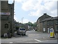
Woodhead Road - viewed from Bridge Street
Image: © Betty Longbottom
Taken: 28 Jun 2010
0.04 miles