IMAGES TAKEN NEAR TO
Primrose Grove, HUDDERSFIELD, HD4 6EB
Introduction
This page details the photographs taken nearby to Primrose Grove, HD4 6EB by members of the Geograph project.
The Geograph project started in 2005 with the aim of publishing, organising and preserving representative images for every square kilometre of Great Britain, Ireland and the Isle of Man.

There are currently over 7.5m images from over14,400 individuals and you can help contribute to the project by visiting https://www.geograph.org.uk
Image Map
Images are licensed for reuse under creativecommons.org/licenses/by-sa/2.0
Notes
- Clicking on the map will re-center to the selected point.
- The higher the marker number, the further away the image location is from the centre of the postcode.
Image Listing (85 Images Found)
Images are licensed for reuse under creativecommons.org/licenses/by-sa/2.0
Image
Details
Distance
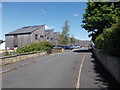
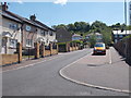
2
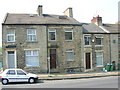
Elizabeth Street - viewed from Ridge Street
Image: © Betty Longbottom
Taken: 24 May 2016
0.05 miles
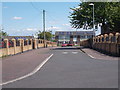
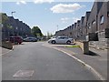
3
Elizabeth Street - viewed from Ridge Street
Image: © Betty Longbottom
Taken: 24 May 2016
0.05 miles
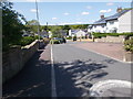
5
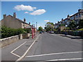
Cross Lane - viewed from Elizabeth Street
Image: © Betty Longbottom
Taken: 24 May 2016
0.06 miles
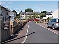
6
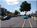
Cross Lane - viewed from Elizabeth Street
Image: © Betty Longbottom
Taken: 24 May 2016
0.08 miles

8
Primrose Hill, Huddersfield
This view of Whitehead Lane shows No. 144 which was a bakery for 40 years (1915-1955) and was run throughout that time by Fred Copley.
Image: © Andrew Loughran
Taken: 9 May 2006
0.13 miles