IMAGES TAKEN NEAR TO
Lockwood Scar, HUDDERSFIELD, HD4 6BW
Introduction
This page details the photographs taken nearby to Lockwood Scar, HD4 6BW by members of the Geograph project.
The Geograph project started in 2005 with the aim of publishing, organising and preserving representative images for every square kilometre of Great Britain, Ireland and the Isle of Man.

There are currently over 7.5m images from over14,400 individuals and you can help contribute to the project by visiting https://www.geograph.org.uk
Image Map
Images are licensed for reuse under creativecommons.org/licenses/by-sa/2.0
Notes
- Clicking on the map will re-center to the selected point.
- The higher the marker number, the further away the image location is from the centre of the postcode.
Image Listing (213 Images Found)
Images are licensed for reuse under creativecommons.org/licenses/by-sa/2.0
Image
Details
Distance
1
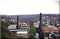
Mills in Lockwood from Primrose Hill
A picture in a book I have states that this is Broadfield Mills but it doesn't say whether that is the mill to the right or left of the River Holme, or both. Broadfield Mills' address is given as Albert Street and that is right. If anybody can help with the shed to the left I would be grateful.
Lockwood viaduct marches across the background and is 129' in the middle and about 1/4 mile long.
Stanley Walker has confirmed that Broadfield Mills is actually on both sides of the river. Another issue resolved - thanks Stanley.
Here is a more recent image - Image - with more trees and fewer chimneys.
Image: © Chris Allen
Taken: 1 May 1988
0.01 miles
2
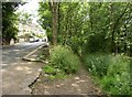
Top of Coal Pit Lane, Salford, Almondbury
This is its junction with Whitehead Lane. Although Coal Pit Lane is no more than a footpath now, it shows signs of having been surfaced, and was presumably used by horses and carts taking coal down to the main road at Lockwood Bridge.
Image: © Humphrey Bolton
Taken: 15 Jun 2006
0.02 miles
3
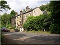
Houses at Spa Wood Top on Whitehead Lane, near Lockwood
On the 1906 1:2500 map the nearest house was only half the present size, so the rear gable must have been added later.
Image: © Humphrey Bolton
Taken: 15 Jun 2006
0.02 miles
4
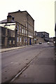
Albert Street, Lockwood
The far end with Bridge Street crossing in the distance.
Perhaps somebody can provide some names for the mills that are visible.
Image: © Chris Allen
Taken: 6 Dec 1987
0.05 miles
5
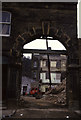
Broadfield Mills demolition, Lockwood
This is the same arch as later photographed by Humphrey BoltonImage It was considerably dirtier in 1987 but the fine detailing is still visible.
Image: © Chris Allen
Taken: 6 Dec 1987
0.05 miles
6
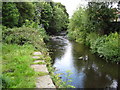
River Holme near Salford, Huddersfield
Image: © Chris Wimbush
Taken: 28 Aug 2010
0.05 miles
7
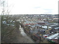
Industrial View
View of Lockwood with the River Holme in the bottom along with the remains of some of the old mills.
Image: © Stanley Walker
Taken: 29 Jan 2007
0.05 miles
8
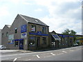
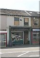
Swift Blinds, Curtains etc - Lockwood Road
Image: © Betty Longbottom
Taken: 28 Jun 2010
0.06 miles
10
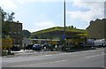
Shine On Car Wash - Lockwood Road
Image: © Betty Longbottom
Taken: 28 Jun 2010
0.07 miles