IMAGES TAKEN NEAR TO
Stone Gate Court, HUDDERSFIELD, HD4 5HR
Introduction
This page details the photographs taken nearby to Stone Gate Court, HD4 5HR by members of the Geograph project.
The Geograph project started in 2005 with the aim of publishing, organising and preserving representative images for every square kilometre of Great Britain, Ireland and the Isle of Man.

There are currently over 7.5m images from over14,400 individuals and you can help contribute to the project by visiting https://www.geograph.org.uk
Image Map
Images are licensed for reuse under creativecommons.org/licenses/by-sa/2.0
Notes
- Clicking on the map will re-center to the selected point.
- The higher the marker number, the further away the image location is from the centre of the postcode.
Image Listing (135 Images Found)
Images are licensed for reuse under creativecommons.org/licenses/by-sa/2.0
Image
Details
Distance
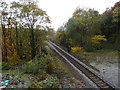
1
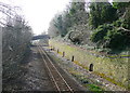
The Huddersfield to Sheffield Railway
Looking southwards from the footbridge off the top of Burbeary Road. The retaining wall has puzzling arched recesses that I have also seen elsewhere. I have been informed that they are "refuges for people at work on the railway in areas of limited clearance. When a train approaches you duck in there until it passes." A track is shown close to the wall on the 1906 1:2500 map. This was the approach to the junction with the Meltham branch line and the normal two tracks were supplemented by slanting 'slip' tracks.
Image: © Humphrey Bolton
Taken: 18 Mar 2015
0.04 miles
2
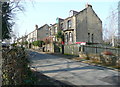
Thornfield Road, from the end of the footpath over the railway
Image: © Humphrey Bolton
Taken: 18 Mar 2015
0.05 miles
3
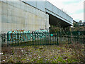
The northern end of the railway path, Beaumont Park, Huddersfield
This is the site of the railway junction where the Meltham branch line left the Penistone line, which is still in use for trains to Sheffield. Presumably the gate is locked, but that does not stop the graffiti artists. The sign on the gate gives the telephone number for the Samaritans.
Image: © Humphrey Bolton
Taken: 21 Feb 2021
0.06 miles
6
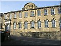
Huddersfield Royal British Legion - Hanson Lane, Lockwood
This was built as a Baptist School in the 1840s and enlarged in the 1860s.
Image: © Betty Longbottom
Taken: 1 Nov 2010
0.06 miles
7
Railway towards Sheffield
Looking south from the bridge on Hanson Lane.
Image: © JThomas
Taken: 8 Nov 2018
0.06 miles
8
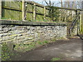
Railway boundary stone off Burbeary Road
LYR stands for Lancashire and Yorkshire Railway. This line from Huddersfield to Sheffield was evidently a branch off the main trans-Pennine route from Manchester to Normanton.
Image: © Humphrey Bolton
Taken: 18 Mar 2015
0.06 miles
9
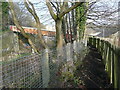
Public footpath from Hanson Lane to Burbeary Road and Thornfield Road
This path runs along the eastern side of the railway, with a drop on both sides. There are steps leading down to Burbeary Road, and a footbridge over the railway, leading to Thornfield Road.
Image: © Humphrey Bolton
Taken: 18 Mar 2015
0.06 miles
10
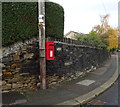
Elizabeth II postbox on Moor End Road
Image: © JThomas
Taken: 8 Nov 2018
0.06 miles