IMAGES TAKEN NEAR TO
Cutter Close, HUDDERSFIELD, HD3 3WY
Introduction
This page details the photographs taken nearby to Cutter Close, HD3 3WY by members of the Geograph project.
The Geograph project started in 2005 with the aim of publishing, organising and preserving representative images for every square kilometre of Great Britain, Ireland and the Isle of Man.

There are currently over 7.5m images from over14,400 individuals and you can help contribute to the project by visiting https://www.geograph.org.uk
Image Map
Images are licensed for reuse under creativecommons.org/licenses/by-sa/2.0
Notes
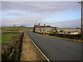
- Clicking on the map will re-center to the selected point.
- The higher the marker number, the further away the image location is from the centre of the postcode.
Image Listing (51 Images Found)
Images are licensed for reuse under creativecommons.org/licenses/by-sa/2.0
Image
Details
Distance
1
Field with kiosk, off Lindley Moor Road, Lindley-cum-Quarmby
Is this one of Dr Who's portals, or is there an EU directive about toilet facilities for farm-workers, or perhaps farm animals? I have been informed that it is used during sheepdog trials that are regularly held in the field.
Image: © Humphrey Bolton
Taken: 26 Apr 2007
0.12 miles
2
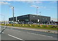
The Land Rover and Jaguar car dealership, Lindley Moor Road, Huddersfield
This dealership has moved from Copley.
Image: © Humphrey Bolton
Taken: 15 Apr 2021
0.12 miles
3
Haigh Cross Farm, Crosland Road, Lindley cum Quarmby
The top of the cross can be seen above an outbuilding, looking rather like a chimney.
Image: © Humphrey Bolton
Taken: 13 Feb 2007
0.14 miles
4
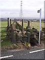
Footpath off Crosland Road, Lindley cum Quarmby
This is opposite Haigh Cross. The footpath runs in a narrow strip between stone walls.
Image: © Humphrey Bolton
Taken: 13 Feb 2007
0.14 miles
5
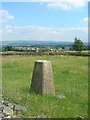
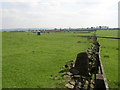
Triangulation Pillar at SE107188
Trig. pillar in field adjacent A643. View is looking about SE over Huddersfield. Emley Moor TV mast in Image can be seen in the distance.
Image: © Ian M
Taken: 11 Jul 2005
0.14 miles
6
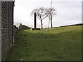
Haigh Cross, Lindley cum Quarmby
This is a 19C replacement for a 14C wayside cross, and is inscribed on the E face, below the Thornhill Arms, 'Re-erected / by / T T / 1808 / After Being / wilfully / pulled down / Haigh Cross'. On the W face is a Cornish Chough in a rectangular panel and below it 'Quarmbys / de / Quarmby / Crest / 1304. T.T. was Thomas Thornhill. (Information from W B Crump, Huddersfield highways down the ages, reprinted 1968).
Image: © Humphrey Bolton
Taken: 13 Feb 2007
0.14 miles
7
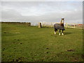
Trig. Station at Haigh Cross, Lindley cum Quarmby
In the same field as Haigh Cross, both guarded by a horse.
Image: © Humphrey Bolton
Taken: 13 Feb 2007
0.14 miles
8
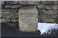
Old Boundary Marker by the A643, Lindley Moor Road
Municipal Boundary Marker by the A643, in parish of Lindley (Kirklees District), Peat Ponds Farm, Lindley Moor Road, against the farmhouse wall.
N.B. The area has been developed for industrial use since 2016, but on Streetview 2019 the stone appears to have been preserved.
Inscription reads:-
DIVISION
OF
LINDLEY
AND
OLD LINDLEY
Grade II listed. List Entry Number: 1134956
https://historicengland.org.uk/listing/the-list/list-entry/1134956
Surveyed
Milestone Society National ID: YW_LIND01pb.
Image: © Milestone Society
Taken: Unknown
0.14 miles
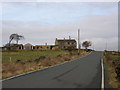
9
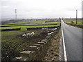
Jericho Farm, Crosland Road, Lindley cum Quarmby
Haigh Cross is in the distance.
Image: © Humphrey Bolton
Taken: 13 Feb 2007
0.15 miles
10
Crosland Road from Haigh Cross, Lindley cum Quarmby
Jericho is the farm in the distance, and beyond that the suburbs of Huddersfield.
Image: © Humphrey Bolton
Taken: 13 Feb 2007
0.15 miles