IMAGES TAKEN NEAR TO
Lindley Moor Road, HUDDERSFIELD, HD3 3UE
Introduction
This page details the photographs taken nearby to Lindley Moor Road, HD3 3UE by members of the Geograph project.
The Geograph project started in 2005 with the aim of publishing, organising and preserving representative images for every square kilometre of Great Britain, Ireland and the Isle of Man.

There are currently over 7.5m images from over14,400 individuals and you can help contribute to the project by visiting https://www.geograph.org.uk
Image Map
Images are licensed for reuse under creativecommons.org/licenses/by-sa/2.0
Notes
- Clicking on the map will re-center to the selected point.
- The higher the marker number, the further away the image location is from the centre of the postcode.
Image Listing (36 Images Found)
Images are licensed for reuse under creativecommons.org/licenses/by-sa/2.0
Image
Details
Distance
1
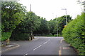
The top end of Laund Road
Where it meets the A643. The M62 runs just behind the trees ahead, and the sound of it cannot be avoided.
Image: © Bill Boaden
Taken: 26 Jun 2013
0.06 miles
3
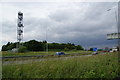
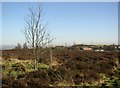
The M62 on Old Lindley Moor
Between Junctions 23 & 24, where there are good views on the far side.
Image: © Bill Boaden
Taken: 26 Jun 2013
0.07 miles
4
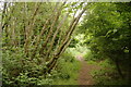
Unofficial footpath between the M62 and Lindley Moor Road
There is no path marked on the map but the footpath has developed in this long strip of woodland shielding the M62 which is to the left.
Image: © Bill Boaden
Taken: 26 Jun 2013
0.08 miles
5
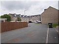
Rafborn Grove - viewed from Rafborn Avenue
Image: © Betty Longbottom
Taken: 16 Jun 2015
0.09 miles
6
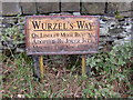
Sign on Old Lindley Moor, Old Lindley
Above the steep escarpment of old Lindley Moor is a flat-topped ridge. This was transferred to Huddersfield CB in 1913, and part of it became a cricket ground, part a 'crippled children's home' and part a 'recreation ground' (as on a 6” map of c.1930). This latter is an area of heather with a driveway to a superb viewpoint. This sign is by the side of the driveway.
Image: © Humphrey Bolton
Taken: 15 Oct 2007
0.10 miles
7
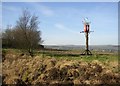
Mystery object, Old Lindley Moor
At first I took this to be a beacon, but it is too decorative on top. Why the Swiss cross?
Image: © Humphrey Bolton
Taken: 12 Feb 2008
0.10 miles
8
Recreation ground, Old Lindley Moor
Captioned thus on the 6 inch map of c.1940, but shown as rough pasture so it was probably never an informal sports ground.
Image: © Humphrey Bolton
Taken: 12 Feb 2008
0.10 miles
9
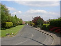
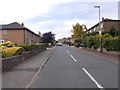
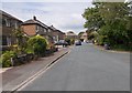
Residential road parallel to Lindley Moor Road, Longwood
A pity that this has not been done more often. The houses are shielded from the main road by trees, and are accessed from a quiet street.
Image: © Humphrey Bolton
Taken: 26 Apr 2007
0.10 miles