IMAGES TAKEN NEAR TO
Crosland Fold, HUDDERSFIELD, HD3 3QH
Introduction
This page details the photographs taken nearby to Crosland Fold, HD3 3QH by members of the Geograph project.
The Geograph project started in 2005 with the aim of publishing, organising and preserving representative images for every square kilometre of Great Britain, Ireland and the Isle of Man.

There are currently over 7.5m images from over14,400 individuals and you can help contribute to the project by visiting https://www.geograph.org.uk
Image Map
Images are licensed for reuse under creativecommons.org/licenses/by-sa/2.0
Notes
- Clicking on the map will re-center to the selected point.
- The higher the marker number, the further away the image location is from the centre of the postcode.
Image Listing (47 Images Found)
Images are licensed for reuse under creativecommons.org/licenses/by-sa/2.0
Image
Details
Distance
1
The Land Rover and Jaguar car dealership, Lindley Moor Road, Huddersfield
This dealership has moved from Copley.
Image: © Humphrey Bolton
Taken: 15 Apr 2021
0.12 miles
2
Field with kiosk, off Lindley Moor Road, Lindley-cum-Quarmby
Is this one of Dr Who's portals, or is there an EU directive about toilet facilities for farm-workers, or perhaps farm animals? I have been informed that it is used during sheepdog trials that are regularly held in the field.
Image: © Humphrey Bolton
Taken: 26 Apr 2007
0.14 miles
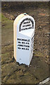
3

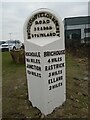
Replacement Milestone, A643, Lindley Moor Road
The milestone is located on the south side of the road, opposite the Wappy Spring public house. Metal plate attached to stone post, WR casting design.
It was erected by Huddersfield Council in 2021 as a replacement for the original milestone that was removed when nearby land was redeveloped. See https://www.geograph.org.uk/photo/6772134. For details of the original milestone, see https://www.geograph.org.uk/photo/6045200.
Inscription reads:- ROCHDALE / 16¼ MILES / JUNCTION / 10¼ MILES :: BRIGHOUSE / 4 MILES / RASTRICK / 3 MILES / ELLAND / 2 MILES :: HUDDERSFIELD & NEW HEY / ROAD / BRANCH / STAINLAND :: HARGREAVES FOUNDRY / HALIFAX / 2019
Milestone Society National ID: YW_BHOU04R
Image: © Milestone Society
Taken: 5 Mar 2021
0.14 miles
4
Replacement Milestone, A643, Lindley Moor Road
The milestone is located on the south side of the road, opposite the Wappy Spring public house. Metal plate attached to stone post, WR casting design.
It was erected by Huddersfield Council in 2021 as a replacement for the original milestone that was removed when nearby land was redeveloped, see https://www.geograph.org.uk/photo/6772134. For details of the original milestone, see https://www.geograph.org.uk/photo/6045200.
Inscription reads:- ROCHDALE / 16¼ MILES / JUNCTION / 10¼ MILES :: BRIGHOUSE / 4 MILES / RASTRICK / 3 MILES / ELLAND / 2 MILES :: HUDDERSFIELD & NEW HEY / ROAD / BRANCH / STAINLAND :: HARGREAVES FOUNDRY / HALIFAX / 2019
Milestone Society National ID: YW_BHOU04R
Image: © Milestone Society
Taken: 5 Mar 2021
0.14 miles
5
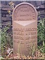
Old Milestone by the A643, Lindley Moor Road, Kirklees Parish
Metal plate attached to stone post by the A643, in parish of KIRKLEES (KIRKLEES District), Lindley Moor Road; opposite Wappy Spring PH, by the road, on South side of road. Brayshaw & Booth iron casting, erected by the County Council in the 19th century.
No longer visible on Streetview in 2019 - now wide entrance to industrial unit.
Inscription reads:- : ROCHDALE / 16¼ MILES / JUNCTION / 10¼ MILES : : HUDDERSFIELD & NEW HEY / ROAD / BRANCH / STAINLAND : : BRIGHOUSE / 4 MILES / RASTRICK / 3 MILES / ELLAND / 2 MILES : : BRAYSHAW & BOOTH / MAKERS / LIVERSEDGE :
Milestone Society National ID: YW_BHOU04.
Image: © C Minto
Taken: 28 Sep 2003
0.14 miles
6
Milestone replacement
The rusty West Riding CC milestone dating from 1893/94, opposite the Wappy Spring PH on the A643 was removed when nearby land was developed. Despite numerous enquiries it was not found. In 2019 a new casting was commissioned by Kirklees Council from the Hargreaves foundry in Halifax. In early 2021 it was set up, attached to a new backing stone, at the original site. The foundry name and date of casting is on the bevel.
Image: © Chris Minto
Taken: 7 Mar 2021
0.14 miles
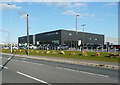
7
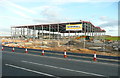
The first building in Summit 24 Business Park, Lindley
This will be a warehouse for Lesjofors Springs Ltd, who are moving from Lowfields Business Park in Elland. Browsing their website I found this article about the involvement of one of the group companies in the Bloodhound land speed record attempt scheduled for October 2017. http://www.lesjoforsab.com/news/news_detail.asp?sprakid=2
The target speed is 1000 mph!
Image: © Humphrey Bolton
Taken: 22 Sep 2016
0.15 miles
8
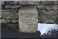
Old Boundary Marker by the A643, Lindley Moor Road
Municipal Boundary Marker by the A643, in parish of Lindley (Kirklees District), Peat Ponds Farm, Lindley Moor Road, against the farmhouse wall.
N.B. The area has been developed for industrial use since 2016, but on Streetview 2019 the stone appears to have been preserved.
Inscription reads:-
DIVISION
OF
LINDLEY
AND
OLD LINDLEY
Grade II listed. List Entry Number: 1134956
https://historicengland.org.uk/listing/the-list/list-entry/1134956
Surveyed
Milestone Society National ID: YW_LIND01pb.
Image: © Milestone Society
Taken: Unknown
0.15 miles
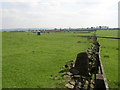
10
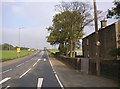
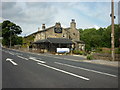
Lindley Moor Road, Old Lindley, at Peat Ponds Farm
The boundary stone in the other photo is against the wall opposite the first tree on the right. Although Old Lindley is now mostly in Calderdale district, a strip of land including the main road was given to Huddersfield many years ago and this scene is now all in Kirklees district.
Image: © Humphrey Bolton
Taken: 16 Oct 2006
0.16 miles