IMAGES TAKEN NEAR TO
Hungerford Road, HUDDERSFIELD, HD3 3AL
Introduction
This page details the photographs taken nearby to Hungerford Road, HD3 3AL by members of the Geograph project.
The Geograph project started in 2005 with the aim of publishing, organising and preserving representative images for every square kilometre of Great Britain, Ireland and the Isle of Man.

There are currently over 7.5m images from over14,400 individuals and you can help contribute to the project by visiting https://www.geograph.org.uk
Image Map
Images are licensed for reuse under creativecommons.org/licenses/by-sa/2.0
Notes
- Clicking on the map will re-center to the selected point.
- The higher the marker number, the further away the image location is from the centre of the postcode.
Image Listing (51 Images Found)
Images are licensed for reuse under creativecommons.org/licenses/by-sa/2.0
Image
Details
Distance
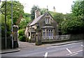
2
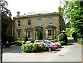
Trafford House - 11 Halifax Road
Now converted into offices
Image: © Betty Longbottom
Taken: 13 May 2008
0.08 miles
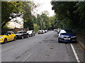
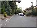
5
Kaffir Road, Edgerton
Heading away from Halifax Road.
Image: © Jaggery
Taken: 26 Sep 2009
0.09 miles
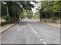
7
Thornhill Road - viewed from Occupation Road
Image: © Betty Longbottom
Taken: 16 Sep 2015
0.10 miles
8
Thornhill Road - viewed from Occupation Road
Image: © Betty Longbottom
Taken: 16 Sep 2015
0.11 miles
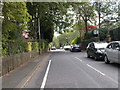
10
Cleveland Road - viewed from Sunny Bank Road
Image: © Betty Longbottom
Taken: 16 Sep 2015
0.11 miles