IMAGES TAKEN NEAR TO
Scale Hill, HUDDERSFIELD, HD2 2PD
Introduction
This page details the photographs taken nearby to Scale Hill, HD2 2PD by members of the Geograph project.
The Geograph project started in 2005 with the aim of publishing, organising and preserving representative images for every square kilometre of Great Britain, Ireland and the Isle of Man.

There are currently over 7.5m images from over14,400 individuals and you can help contribute to the project by visiting https://www.geograph.org.uk
Image Map (Loading...)


Getting Data...Please wait
Leaflet Map data © OpenStreetMap
Images are licensed for reuse under creativecommons.org/licenses/by-sa/2.0
Notes
- Clicking on the map will re-center to the selected point.
- The higher the marker number, the further away the image location is from the centre of the postcode.
Image Listing (84 Images Found)
Images are licensed for reuse under creativecommons.org/licenses/by-sa/2.0
Image
Details
Distance
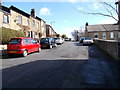
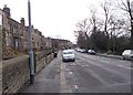
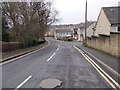
2
Clough Road - viewed from Scale Hill
Image: © Betty Longbottom
Taken: 31 Mar 2015
0.04 miles
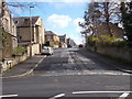
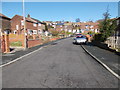
3
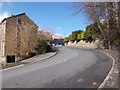
Cowcliffe Hill Road - viewed from Scale Hill
Image: © Betty Longbottom
Taken: 31 Mar 2015
0.05 miles
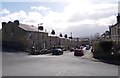
5
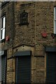
Corner shops
At the bottom of Cowcliffe Hill Road, the junction with Halifax Old Road, it looks like this may at one time have been a corner shop?
Image: © Terry
Taken: 8 May 2023
0.09 miles
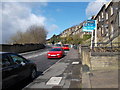
6
Halifax Old Road - viewed from Cowcliffe Hill Road
Image: © Betty Longbottom
Taken: 31 Mar 2015
0.09 miles
8
Halifax Old Road - viewed from Cowcliffe Hill Road
Image: © Betty Longbottom
Taken: 31 Mar 2015
0.09 miles
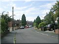
10
Pateley Crescent - looking towards York Avenue
Image: © Betty Longbottom
Taken: 31 Mar 2015
0.11 miles