IMAGES TAKEN NEAR TO
Sunningdale Croft, HUDDERSFIELD, HD2 2NX
Introduction
This page details the photographs taken nearby to Sunningdale Croft, HD2 2NX by members of the Geograph project.
The Geograph project started in 2005 with the aim of publishing, organising and preserving representative images for every square kilometre of Great Britain, Ireland and the Isle of Man.

There are currently over 7.5m images from over14,400 individuals and you can help contribute to the project by visiting https://www.geograph.org.uk
Image Map (Loading...)


Getting Data...Please wait
Leaflet Map data © OpenStreetMap
Images are licensed for reuse under creativecommons.org/licenses/by-sa/2.0
Notes
- Clicking on the map will re-center to the selected point.
- The higher the marker number, the further away the image location is from the centre of the postcode.
Image Listing (53 Images Found)
Images are licensed for reuse under creativecommons.org/licenses/by-sa/2.0
Image
Details
Distance
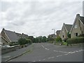
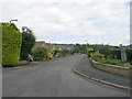
1
Kirklees Way at Gleneagles Way, Top of Cowcliffe
Image: © Ian S
Taken: 25 Apr 2018
0.05 miles
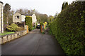
7
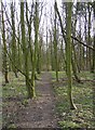
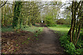
Path through woodland, Fixby
This path runs parallel to the public footpath, through a shelter-belt of trees at the edge of Fixby Park.
Image: © Humphrey Bolton
Taken: 8 Mar 2007
0.10 miles
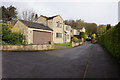
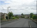
8
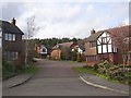
Estate off Ganton Way, Fixby
A late 20C cul-de-sac off the top end of Ganton Way.
Image: © Humphrey Bolton
Taken: 8 Mar 2007
0.10 miles