IMAGES TAKEN NEAR TO
Netheroyd Hill Road, HUDDERSFIELD, HD2 2LZ
Introduction
This page details the photographs taken nearby to Netheroyd Hill Road, HD2 2LZ by members of the Geograph project.
The Geograph project started in 2005 with the aim of publishing, organising and preserving representative images for every square kilometre of Great Britain, Ireland and the Isle of Man.

There are currently over 7.5m images from over14,400 individuals and you can help contribute to the project by visiting https://www.geograph.org.uk
Image Map (Loading...)


Getting Data...Please wait
Leaflet Map data © OpenStreetMap
Images are licensed for reuse under creativecommons.org/licenses/by-sa/2.0
Notes
- Clicking on the map will re-center to the selected point.
- The higher the marker number, the further away the image location is from the centre of the postcode.
Image Listing (68 Images Found)
Images are licensed for reuse under creativecommons.org/licenses/by-sa/2.0
Image
Details
Distance
2
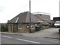
Cowcliffe and Netheroyd Hill Liberal Club, Fartown
Dated 1924
Image: © Humphrey Bolton
Taken: 28 Apr 2006
0.06 miles
3
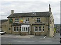
Shepherds Arms - Cowcliffe Hill Road
Image: © Betty Longbottom
Taken: 7 Aug 2009
0.06 miles
4
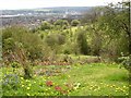
Viewpoint, Netheroyd Hill Liberal Club, Fartown
Here is the view from a roadside seat. Someone has made a little garden to augment the dandelions that are omnipresent at this time of year. The land in the middle distance is becoming a wood. The most prominent buildings in the distance are the Galpharm stadium and the waste incinerator chimney.
Image: © Humphrey Bolton
Taken: 28 Apr 2006
0.07 miles
5
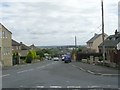
Nether Royd Hill Road - Cowcliffe Hill Road
Image: © Betty Longbottom
Taken: 7 Aug 2009
0.07 miles
6
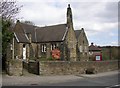
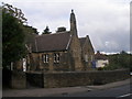
St Hilda's Church, Netheroyd Hill, Fartown
The foundation stone was laid in 1919, and a mid-20C map shows it as a school.
Image: © Humphrey Bolton
Taken: 28 Apr 2006
0.07 miles
7

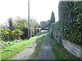
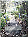
Footpath next to St Hilda's Church, Netheroyd Hill, Fartown
This footpath was originally the usual width of around four feet, but the trees that have been allowed to grow have made it much narrower.
Image: © Humphrey Bolton
Taken: 28 Apr 2006
0.07 miles
8
Footpath & Steps - Cowcliffe Hill Road
Image: © Betty Longbottom
Taken: 29 Oct 2014
0.10 miles
10
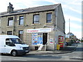
Cowcliffe Convenience Store - Cowcliffe Hill Road
Image: © Betty Longbottom
Taken: 29 Oct 2014
0.11 miles