IMAGES TAKEN NEAR TO
Spinneyfield, HUDDERSFIELD, HD2 2HX
Introduction
This page details the photographs taken nearby to Spinneyfield, HD2 2HX by members of the Geograph project.
The Geograph project started in 2005 with the aim of publishing, organising and preserving representative images for every square kilometre of Great Britain, Ireland and the Isle of Man.

There are currently over 7.5m images from over14,400 individuals and you can help contribute to the project by visiting https://www.geograph.org.uk
Image Map (79 Images)


Getting Data...Please wait
Leaflet Map data © OpenStreetMap
Images are licensed for reuse under creativecommons.org/licenses/by-sa/2.0
Notes
- Clicking on the map will re-center to the selected point.
- The higher the marker number, the further away the image location is from the centre of the postcode.
Image Listing (79 Images Found)
Images are licensed for reuse under creativecommons.org/licenses/by-sa/2.0
Image
Details
Distance
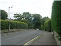
2
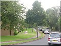
Netheroyd Hill Road - viewed from Lightridge Road
Image: © Betty Longbottom
Taken: 7 Aug 2009
0.03 miles
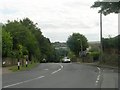
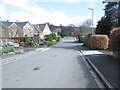
3
Netheroyd Hill Road - looking towards Bradford Road
Image: © Betty Longbottom
Taken: 29 Oct 2014
0.05 miles
5
Netherwood Close - Nether Royd Hill Road
Image: © Betty Longbottom
Taken: 7 Aug 2009
0.07 miles
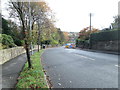
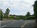
7
The Fairway - viewed from Spinneyfield
Image: © Betty Longbottom
Taken: 1 Apr 2014
0.07 miles
9

Southlands Drive - Nether Royd Hill Road
Image: © Betty Longbottom
Taken: 7 Aug 2009
0.08 miles
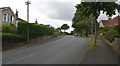
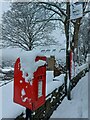
10

Judy Lane, Fartown
This relic of the past is just off the A641 Bradford Road. It passes the back of the Ash Brow pub and meets Lightridge Road.
Image: © Humphrey Bolton
Taken: 19 Aug 2005
0.08 miles