IMAGES TAKEN NEAR TO
Broomfield Road, HUDDERSFIELD, HD2 2HQ
Introduction
This page details the photographs taken nearby to Broomfield Road, HD2 2HQ by members of the Geograph project.
The Geograph project started in 2005 with the aim of publishing, organising and preserving representative images for every square kilometre of Great Britain, Ireland and the Isle of Man.

There are currently over 7.5m images from over14,400 individuals and you can help contribute to the project by visiting https://www.geograph.org.uk
Image Map
Images are licensed for reuse under creativecommons.org/licenses/by-sa/2.0
Notes
- Clicking on the map will re-center to the selected point.
- The higher the marker number, the further away the image location is from the centre of the postcode.
Image Listing (65 Images Found)
Images are licensed for reuse under creativecommons.org/licenses/by-sa/2.0
Image
Details
Distance
1
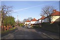
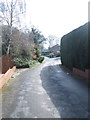
Broomfield Road, Fixby, looking northwards
This part of Broomfield Road was a narrow lane in 1895. Part of the wall surrounding the grounds of Broomfield House can be seen on the right, and the pillar box opposite the shop on Fixby Road is in the distance.
Image: © Humphrey Bolton
Taken: 14 Jan 2007
0.02 miles
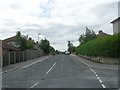
2
Broomfield Road, Fixby, looking southwards
This road is on the line of the drive to Broomfield House, the garage of which is on the left.
Image: © Humphrey Bolton
Taken: 14 Jan 2007
0.02 miles
3
Saint Francis Gardens, Fixby
This housing development was built in the grounds of Broomfield House.
Image: © Humphrey Bolton
Taken: 14 Jan 2007
0.04 miles
4
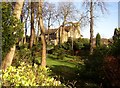
Broomfield House, Fixby
The Italianate tower suggests that this was built as a mill-owner's house in the late 19C.
Image: © Humphrey Bolton
Taken: 14 Jan 2007
0.04 miles
5
The former tramway, Fixby
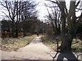
There were difficulties in finding a route through Fixby for the tram route from Huddersfield to Brighouse via Rastrick, and a private line on wooden sleepers was made across what were then fields from New Inn on Bradford Road to Fixby Road. Services started on 12th March 1923. Conversion to trolley-buses took place in 1940. The line became obsolete when Bradford Road and Fixby Road were widened and buses took over. This driveway and public footpath at the NW end is the only remaining part of the tramway.
Image: © Humphrey Bolton
Taken: 22 Mar 2006
0.08 miles
6
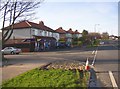
The Nisa shop, Fixby Road, Fixby
This small supermarket is Fixby's only shop. I shall watch the patch of hardcore in the foreground with interest!
Image: © Humphrey Bolton
Taken: 14 Jan 2007
0.08 miles
7
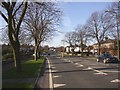
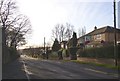
Fixby Road, Bradley / Fixby
Fixby Road passes from Bradley into Fixby at the Broomfield Road junction, just after the '30 limit' signs. The main road then becomes Clough Lane as it bends to the right. Taken from between the church and the crematorium.
Image: © Humphrey Bolton
Taken: 14 Jan 2007
0.08 miles
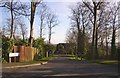
10

Entrance to Huddersfield Crematorium, Bradley
The grounds look to be pleasantly landscaped, but I haven't yet ventured inside. The building at the entrance has the flat roof popular around the 1960s, before it was found that this type of roof tends to leak!
Image: © Humphrey Bolton
Taken: 14 Jan 2007
0.10 miles