IMAGES TAKEN NEAR TO
Beechwood Grove, HUDDERSFIELD, HD2 2FF
Introduction
This page details the photographs taken nearby to Beechwood Grove, HD2 2FF by members of the Geograph project.
The Geograph project started in 2005 with the aim of publishing, organising and preserving representative images for every square kilometre of Great Britain, Ireland and the Isle of Man.

There are currently over 7.5m images from over14,400 individuals and you can help contribute to the project by visiting https://www.geograph.org.uk
Image Map (Loading...)


Getting Data...Please wait
Leaflet Map data © OpenStreetMap
Images are licensed for reuse under creativecommons.org/licenses/by-sa/2.0
Notes
- Clicking on the map will re-center to the selected point.
- The higher the marker number, the further away the image location is from the centre of the postcode.
Image Listing (90 Images Found)
Images are licensed for reuse under creativecommons.org/licenses/by-sa/2.0
Image
Details
Distance
1
Jilly Royd Lane, Fixby
A bridleway from Jilly Royd and Upper Fell Greave (wood) to Lightridge Road. The Fixby township boundary was along the eastern (left) side.
Image: © Humphrey Bolton
Taken: 28 Apr 2006
0.02 miles
2
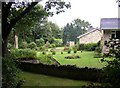
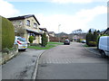
Bungalows on the site of Jilley Royd, Fixby
Jilley (or Gilly) Royd was an ancient settlement in the north-eastern corner of Fixby, next to Upper Fell Greave (wood) in Bradley, from which this photo is taken. The house had been turned into a row of cottages, and has now been demolished and replaced by bungalows. In the garden on the left there is a tall sculpture, and somewhere in the lawn there was a well.
Image: © Humphrey Bolton
Taken: 1 Sep 2006
0.02 miles
3
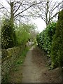
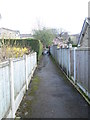
Footpath in Fixby, near Jilly Royd House
Image: © yorkshirelad
Taken: 29 Jan 2021
0.04 miles
8
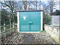
Electricity Substation No 536 - Jilley Royd Lane
Image: © Betty Longbottom
Taken: 1 Apr 2014
0.08 miles
9
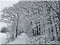
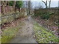
Path / road alongside Upper Fell Greave Woods in snow
Image: © yorkshirelad
Taken: 14 Jan 2021
0.09 miles
10
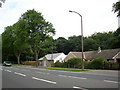
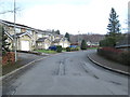
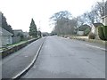
Houses, Fixby Road, Bradley
The road was built up on an embankment here, and the houses have a lower storey at the back. The house on the left was completed recently (2007). The woodland beyond is Upper Fell Greave.
Image: © Humphrey Bolton
Taken: 18 Jun 2007
0.11 miles