IMAGES TAKEN NEAR TO
Fixby, HUDDERSFIELD, HD2 2EW
Introduction
This page details the photographs taken nearby to HD2 2EW by members of the Geograph project.
The Geograph project started in 2005 with the aim of publishing, organising and preserving representative images for every square kilometre of Great Britain, Ireland and the Isle of Man.

There are currently over 7.5m images from over14,400 individuals and you can help contribute to the project by visiting https://www.geograph.org.uk
Image Map (Loading...)


Getting Data...Please wait
Leaflet Map data © OpenStreetMap
Images are licensed for reuse under creativecommons.org/licenses/by-sa/2.0
Notes
- Clicking on the map will re-center to the selected point.
- The higher the marker number, the further away the image location is from the centre of the postcode.
Image Listing (37 Images Found)
Images are licensed for reuse under creativecommons.org/licenses/by-sa/2.0
Image
Details
Distance
6
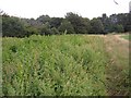
Manure heap near Upper Cote, Fixby
Alongside the footpath there is a dense patch of vegetation, and amongst it are piles of straw and manure.
Image: © Humphrey Bolton
Taken: 23 Aug 2006
0.04 miles
7
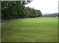
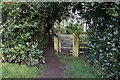
Wall and ditch around Fixby Golf Course
This is rather like a haha (which is a hidden boundary between the parkland around a mansion and the adjacent fields) but in reverse in that the wall is on the outside rather than the ditch. It was perhaps built when the golf course was made in Fixby Park c.1891.
Image: © Humphrey Bolton
Taken: 23 Aug 2006
0.04 miles
8
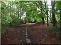
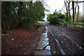
Footpath across Gernhill Wood, Fixby Estate
This footpath might be the original route from Rastrick and Elland to Huddersfield. The causey stones (half buried) suggest that horses used this route, but by the time vehicles such as stage coaches came along a road had been made around the perimeter of Fixby Park.
Image: © Humphrey Bolton
Taken: 23 Aug 2006
0.04 miles