IMAGES TAKEN NEAR TO
Blacker Road, HUDDERSFIELD, HD2 2AA
Introduction
This page details the photographs taken nearby to Blacker Road, HD2 2AA by members of the Geograph project.
The Geograph project started in 2005 with the aim of publishing, organising and preserving representative images for every square kilometre of Great Britain, Ireland and the Isle of Man.

There are currently over 7.5m images from over14,400 individuals and you can help contribute to the project by visiting https://www.geograph.org.uk
Image Map (Loading...)


Getting Data...Please wait
Leaflet Map data © OpenStreetMap
Images are licensed for reuse under creativecommons.org/licenses/by-sa/2.0
Notes
- Clicking on the map will re-center to the selected point.
- The higher the marker number, the further away the image location is from the centre of the postcode.
Image Listing (109 Images Found)
Images are licensed for reuse under creativecommons.org/licenses/by-sa/2.0
Image
Details
Distance
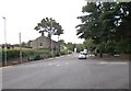
1
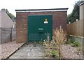
Electricity Substation No 1022 - Blacker Road
Image: © Betty Longbottom
Taken: 24 Aug 2015
0.01 miles
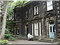
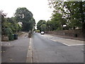
2
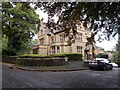
Blacker Road down to Birkby
On the right is the firm of Robertson Memorials and behind the high stone wall on the right a very large cemetery
Image: © Martin Dawes
Taken: 27 Mar 2017
0.01 miles
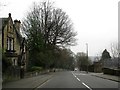
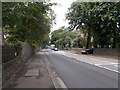
5
Edgerton Road - viewed from Blacker Road
Image: © Betty Longbottom
Taken: 24 Aug 2015
0.03 miles
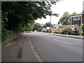
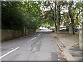
6
Edgerton Road - viewed from Blacker Road
Image: © Betty Longbottom
Taken: 24 Aug 2015
0.04 miles
7
Edgerton Grove Road - Edgerton Road
Image: © Betty Longbottom
Taken: 24 Aug 2015
0.05 miles
10
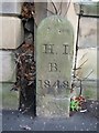
Old Boundary Marker by the A629, New North Road, Huddersfield
Parish Boundary Marker by the A629, in parish of Huddersfield (Kirklees District), New North Road.
Lost between June 2017 and June 2018.
Inscription reads:-
H.I.
B
1848
Surveyed
Milestone Society National ID: YW_HIB02pb
Image: © Milestone Society
Taken: Unknown
0.08 miles