IMAGES TAKEN NEAR TO
Spindle Walk, HD2 1ZN
Introduction
This page details the photographs taken nearby to Spindle Walk, HD2 1ZN by members of the Geograph project.
The Geograph project started in 2005 with the aim of publishing, organising and preserving representative images for every square kilometre of Great Britain, Ireland and the Isle of Man.

There are currently over 7.5m images from over14,400 individuals and you can help contribute to the project by visiting https://www.geograph.org.uk
Image Map (Loading...)


Getting Data...Please wait
Leaflet Map data © OpenStreetMap
Images are licensed for reuse under creativecommons.org/licenses/by-sa/2.0
Notes
- Clicking on the map will re-center to the selected point.
- The higher the marker number, the further away the image location is from the centre of the postcode.
Image Listing (76 Images Found)
Images are licensed for reuse under creativecommons.org/licenses/by-sa/2.0
Image
Details
Distance
4
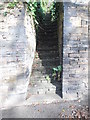
Steps, Ashbrow Road
The steps form a public footpath linking the main route of Ashbrow Road with a spur of it that runs higher up the slope.
Image: © habiloid
Taken: 25 Jan 2020
0.07 miles
6
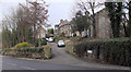
Ash Brow Road - viewed from Bradley Boulevard
Image: © Betty Longbottom
Taken: 29 Oct 2014
0.08 miles
10
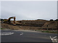
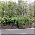
Early construction of new housing estate off Ashbrow Road
Image: © yorkshirelad
Taken: 16 Sep 2020
0.09 miles