IMAGES TAKEN NEAR TO
Suffolk Rise, HUDDERSFIELD, HD2 1ZG
Introduction
This page details the photographs taken nearby to Suffolk Rise, HD2 1ZG by members of the Geograph project.
The Geograph project started in 2005 with the aim of publishing, organising and preserving representative images for every square kilometre of Great Britain, Ireland and the Isle of Man.

There are currently over 7.5m images from over14,400 individuals and you can help contribute to the project by visiting https://www.geograph.org.uk
Image Map (Loading...)


Getting Data...Please wait
Leaflet Map data © OpenStreetMap
Images are licensed for reuse under creativecommons.org/licenses/by-sa/2.0
Notes
- Clicking on the map will re-center to the selected point.
- The higher the marker number, the further away the image location is from the centre of the postcode.
Image Listing (81 Images Found)
Images are licensed for reuse under creativecommons.org/licenses/by-sa/2.0
Image
Details
Distance
2
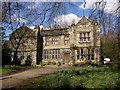
Newhouse Hall, Sheepridge, Fartown, Huddersfield
Thomas Brooke of Deighton was granted land on Sheepridge Common in 1521 and built a house there that became known as the 'New House'. He farmed the land and was also a clothier. A later Thomas Brooke built the west wing (on the left side in the photograph) c.1630. ‘Hall’ was probably added to the name by Sir John William Ramsden in the mid-19C. The east wing was damaged by a fire, and was eventually rebuild in 1893, hence the large windows.
Image: © Humphrey Bolton
Taken: 21 Mar 2007
0.03 miles
3
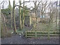
Footpath past Newhouse Hall, Sheepridge, Fartown, Huddersfield
Newhouse Hall was built in the period 1530-50, and altered c.1620 and again at the end of the 19C. There is 17C woodwork and plasterwork inside. The name was New House until 'Hall' was added in the 19C. On the right there was New House Farm, now flattened. The public footpath is from Lower Fell Greave, from where the photograph was taken, to New House Road.
Image: © Humphrey Bolton
Taken: 27 Jan 2007
0.03 miles
4
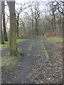
Public footpath in Lower Fell Greave, Bradley, Huddersfield
The path here must have been important at one time, as it has been surfaced in stone
; the edging stones have survived for only a short distance, however.
Image: © Humphrey Bolton
Taken: 27 Jan 2007
0.03 miles
7
Redevelopment of the Brackenhall estate, Fartown, Huddersfield
The council estate had become such a bad area that no-one would accept the houses that had become vacant. The solution was to demolish the estate and redevelop it with owner-occupied houses (although there are some flats to let). The area on the left has not yet been rebuilt.
Image: © Humphrey Bolton
Taken: 5 Mar 2007
0.07 miles
8
Our Lady of Lourdes Catholic Primary School - Bradley Boulevard
Image: © Betty Longbottom
Taken: 7 Aug 2009
0.09 miles
9
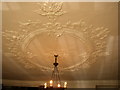
Plaster ceiling in Newhouse Hall, Sheepridge, Fartown, Huddersfield
This is in the main ground-floor room. English Heritage and Pevsner both state that it is late 17C, but an expert on ceilings has identified it as being the work of Thomas Gumby, who worked in this part of Yorkshire during the period 1620 to 1650. This would correspond to modernisation of the house by Thomas Brooke IV, a wealthy clothier, who probably wanted the latest fashion: a hall with a ceiling rather than open to the rafters. There are two putti (child angels) in the centre, an pineapples (symbol of prosperity) around the edge.
Image: © Humphrey Bolton
Taken: 10 Mar 2007
0.09 miles
10
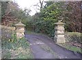
Gateposts, Newhouse Hall, Sheepridge, Fartown, Huddersfield
Very solid gateposts with a decoration of crosses on the projecting stones.
Image: © Humphrey Bolton
Taken: 27 Jan 2007
0.09 miles