IMAGES TAKEN NEAR TO
Stutely Grove, HUDDERSFIELD, HD2 1SA
Introduction
This page details the photographs taken nearby to Stutely Grove, HD2 1SA by members of the Geograph project.
The Geograph project started in 2005 with the aim of publishing, organising and preserving representative images for every square kilometre of Great Britain, Ireland and the Isle of Man.

There are currently over 7.5m images from over14,400 individuals and you can help contribute to the project by visiting https://www.geograph.org.uk
Image Map (Loading...)


Getting Data...Please wait
Leaflet Map data © OpenStreetMap
Images are licensed for reuse under creativecommons.org/licenses/by-sa/2.0
Notes
- Clicking on the map will re-center to the selected point.
- The higher the marker number, the further away the image location is from the centre of the postcode.
Image Listing (62 Images Found)
Images are licensed for reuse under creativecommons.org/licenses/by-sa/2.0
Image
Details
Distance
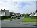
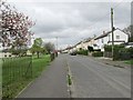
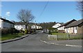
2
Stutely Grove - looking towards Alandale Road
Image: © Betty Longbottom
Taken: 17 Apr 2014
0.03 miles
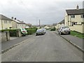
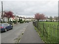
6
Wilton Avenue - viewed from White Cross
Image: © Betty Longbottom
Taken: 17 Apr 2014
0.09 miles
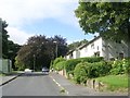
7
Wilton Avenue - viewed from White Cross
Image: © Betty Longbottom
Taken: 17 Apr 2014
0.09 miles
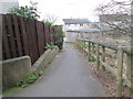
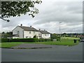
10
Woodville Place, Bradley
At the edge of a large council estate.
Image: © Humphrey Bolton
Taken: 9 Mar 2010
0.11 miles