IMAGES TAKEN NEAR TO
Parkstone, HUDDERSFIELD, HD2 1QL
Introduction
This page details the photographs taken nearby to Parkstone, HD2 1QL by members of the Geograph project.
The Geograph project started in 2005 with the aim of publishing, organising and preserving representative images for every square kilometre of Great Britain, Ireland and the Isle of Man.

There are currently over 7.5m images from over14,400 individuals and you can help contribute to the project by visiting https://www.geograph.org.uk
Image Map (Loading...)


Getting Data...Please wait
Leaflet Map data © OpenStreetMap
Images are licensed for reuse under creativecommons.org/licenses/by-sa/2.0
Notes
- Clicking on the map will re-center to the selected point.
- The higher the marker number, the further away the image location is from the centre of the postcode.
Image Listing (61 Images Found)
Images are licensed for reuse under creativecommons.org/licenses/by-sa/2.0
Image
Details
Distance
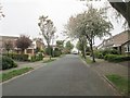
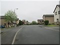
1
Parkstone - looking towards Park Hill
Image: © Betty Longbottom
Taken: 25 Apr 2014
0.02 miles
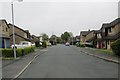
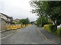
4
Bent Lea - looking towards Park Hill
Image: © Betty Longbottom
Taken: 25 Apr 2014
0.06 miles
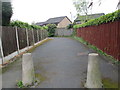
5
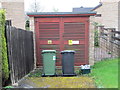
Electricity Substation No 3075 - Park Hill
Image: © Betty Longbottom
Taken: 25 Apr 2014
0.06 miles
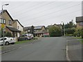
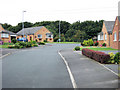
7

Park Lea, Bradley - The Crest
This shot taken at the junction of Park Hill and The Crest shows the typical style of housing in this part of the Park Lea housing estate.
Image: © David Ward
Taken: 23 Jul 2007
0.07 miles
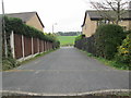
9
Park Lea - Clifton Side
An attractive street on the edge of the Park Lea estate right on the edge of the country.
Image: © David Ward
Taken: 23 Jul 2007
0.07 miles