IMAGES TAKEN NEAR TO
Park Lea, HUDDERSFIELD, HD2 1QH
Introduction
This page details the photographs taken nearby to Park Lea, HD2 1QH by members of the Geograph project.
The Geograph project started in 2005 with the aim of publishing, organising and preserving representative images for every square kilometre of Great Britain, Ireland and the Isle of Man.

There are currently over 7.5m images from over14,400 individuals and you can help contribute to the project by visiting https://www.geograph.org.uk
Image Map (Loading...)


Getting Data...Please wait
Leaflet Map data © OpenStreetMap
Images are licensed for reuse under creativecommons.org/licenses/by-sa/2.0
Notes
- Clicking on the map will re-center to the selected point.
- The higher the marker number, the further away the image location is from the centre of the postcode.
Image Listing (77 Images Found)
Images are licensed for reuse under creativecommons.org/licenses/by-sa/2.0
Image
Details
Distance
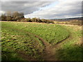
3
Bridleway known as Steep Lane - Park Lea
Image: © Betty Longbottom
Taken: 25 Apr 2014
0.02 miles
4
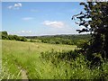
Farmland by the Kirklees Way
Photo taken looking toward Clifton across fields from the Kirklees Way bridleway. The woodland in the background, to the right of the photo, is Kirklees Park, the site of Robin Hood's Grave.
Image: © Tim Marchant
Taken: 1 Jul 2008
0.03 miles
5
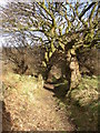
Steep Lane, Bradley, Huddersfield
Here the bridleway steepens and becomes enclosed by banks with trees.
Image: © Humphrey Bolton
Taken: 26 Feb 2007
0.03 miles
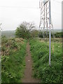
7
Steep Lane, Bradley, Huddersfield
This is the top of the rural section of the bridleway, from just below the junction with Park Lea.
Image: © Humphrey Bolton
Taken: 26 Feb 2007
0.05 miles
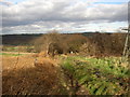
8
Paths across the field, off Steep Lane, Bradley, Huddersfield
The area leading to woodland on Park Hill. They are not rights-of-way, and I call them 'dog-walkers' paths'. They seem to be a common feature at the edge of suburbia.
Image: © Humphrey Bolton
Taken: 26 Feb 2007
0.05 miles
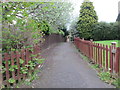
9
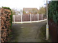
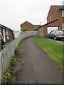
A suburban path junction, Bradley, Huddersfield
This is part of Steep Lane, now engulfed in suburbia, but preserved between the estate roads. The waymark indicates that the bridleway (should be a blue arrow!), which is part of the Kirklees Way (indicated by the 'K') goes to the right, and an estate footpath goes off to the left.
Image: © Humphrey Bolton
Taken: 26 Feb 2007
0.06 miles