IMAGES TAKEN NEAR TO
Fell Greave Road, HUDDERSFIELD, HD2 1NH
Introduction
This page details the photographs taken nearby to Fell Greave Road, HD2 1NH by members of the Geograph project.
The Geograph project started in 2005 with the aim of publishing, organising and preserving representative images for every square kilometre of Great Britain, Ireland and the Isle of Man.

There are currently over 7.5m images from over14,400 individuals and you can help contribute to the project by visiting https://www.geograph.org.uk
Image Map (Loading...)


Getting Data...Please wait
Leaflet Map data © OpenStreetMap
Images are licensed for reuse under creativecommons.org/licenses/by-sa/2.0
Notes
- Clicking on the map will re-center to the selected point.
- The higher the marker number, the further away the image location is from the centre of the postcode.
Image Listing (93 Images Found)
Images are licensed for reuse under creativecommons.org/licenses/by-sa/2.0
Image
Details
Distance
3
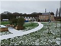
Forget-me-not Children's Hospice, Huddersfield
A controversial development in a 'green' strip between the ribbon development off Bradley Road and a large housing estate in Fartown.
Image: © Humphrey Bolton
Taken: 20 Apr 2012
0.04 miles
4
Forget-me-not Children's Hospice, Huddersfield
A controversial development in a 'green' strip between the ribbon development off Bradley Road and a large housing estate in Fartown.
Image: © Humphrey Bolton
Taken: 20 Apr 2012
0.04 miles
5
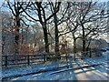
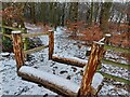
Lower Fell Greave Woods, looking from road
Image: © yorkshirelad
Taken: 9 Jan 2021
0.04 miles
6
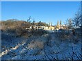
Lower Fell Greave Woods, looking towards Forget Me Knot Hospice
Image: © yorkshirelad
Taken: 9 Jan 2021
0.05 miles
8
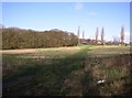
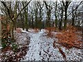
Field at Fell Greave, Bradley, Huddersfield
This unfenced field is cut for silage. The path across it is an unofficial short cut. It is an open space linking the Lower and Upper Fell Greave woods. There is a planning application notice for a children's hospice on the site. A difficult decision has to be made.
Image: © Humphrey Bolton
Taken: 5 Mar 2007
0.06 miles
9
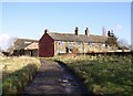
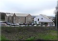
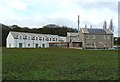
Fell Greave, Bradley, Huddersfield
The farmhouse (on the right of the photo) & middle house were built sometime in the 1600's but the house on the left was added on at a later date & possibly used as a granary to begin with. There are connecting doors upstairs & down between the farmhouse & next door. In the farmhouse living room were a set of bells attached to the wall in what was probably the servants kitchen. (Information from Sue Craner, who used to live there)
Behind there is a barn that has been converted into a house, and there are various out-buildings. The track is Fell Greave Road, a byway.
Image: © Humphrey Bolton
Taken: 5 Mar 2007
0.06 miles