IMAGES TAKEN NEAR TO
Sheepridge Road, HUDDERSFIELD, HD2 1HA
Introduction
This page details the photographs taken nearby to Sheepridge Road, HD2 1HA by members of the Geograph project.
The Geograph project started in 2005 with the aim of publishing, organising and preserving representative images for every square kilometre of Great Britain, Ireland and the Isle of Man.

There are currently over 7.5m images from over14,400 individuals and you can help contribute to the project by visiting https://www.geograph.org.uk
Image Map (Loading...)


Getting Data...Please wait
Leaflet Map data © OpenStreetMap
Images are licensed for reuse under creativecommons.org/licenses/by-sa/2.0
Notes
- Clicking on the map will re-center to the selected point.
- The higher the marker number, the further away the image location is from the centre of the postcode.
Image Listing (83 Images Found)
Images are licensed for reuse under creativecommons.org/licenses/by-sa/2.0
Image
Details
Distance
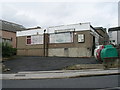
1
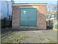
Electricity Substation No 436 - Sheepridge Road
Image: © Betty Longbottom
Taken: 5 Nov 2014
0.01 miles
2
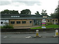
The Chestnut Centre - Sheepridge Road
Image: © Betty Longbottom
Taken: 18 Aug 2008
0.01 miles
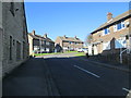
5
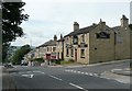
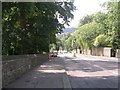
The Fleece, Woodhouse Hill, Fartown, Huddersfield
This might have been built when this was still the main road out of Huddersfield towards Leeds.
Image: © Humphrey Bolton
Taken: 23 Jun 2008
0.04 miles
7
Deighton & Sheepridge Conservative Club - Sheepridge Road
Image: © Betty Longbottom
Taken: 18 Aug 2008
0.05 miles
8
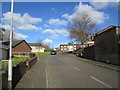
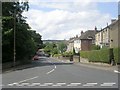
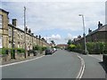
Woodhouse Hill - viewed from Ash Brow Road
Image: © Betty Longbottom
Taken: 7 Aug 2009
0.05 miles
9
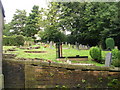
Christ Church, Woodhouse Graveyard - Woodhouse Hill
Image: © Betty Longbottom
Taken: 18 Aug 2008
0.06 miles