IMAGES TAKEN NEAR TO
Marlington Drive, HUDDERSFIELD, HD2 1GU
Introduction
This page details the photographs taken nearby to Marlington Drive, HD2 1GU by members of the Geograph project.
The Geograph project started in 2005 with the aim of publishing, organising and preserving representative images for every square kilometre of Great Britain, Ireland and the Isle of Man.

There are currently over 7.5m images from over14,400 individuals and you can help contribute to the project by visiting https://www.geograph.org.uk
Image Map (Loading...)


Getting Data...Please wait
Leaflet Map data © OpenStreetMap
Images are licensed for reuse under creativecommons.org/licenses/by-sa/2.0
Notes
- Clicking on the map will re-center to the selected point.
- The higher the marker number, the further away the image location is from the centre of the postcode.
Image Listing (106 Images Found)
Images are licensed for reuse under creativecommons.org/licenses/by-sa/2.0
Image
Details
Distance
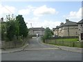
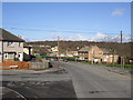
1
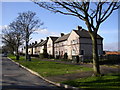
Council houses, Bradley Boulevard, Sheepridge, Fartown, Huddersfield
From the name, this road was intended to link the Sheepridge and Brackenhall housing estates with the one at Bradley, but this never happened. This is perhaps fortunate as it would have probably have become busy with through traffic.
Image: © Humphrey Bolton
Taken: 5 Mar 2007
0.03 miles
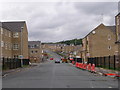
3
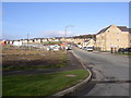
Redevelopment of the Brackenhall estate, Fartown, Huddersfield
The council estate had become such a bad area that no-one would accept the houses that had become vacant. The solution was to demolish the estate and redevelop it with owner-occupied houses (although there are some flats to let). The area on the left has not yet been rebuilt.
Image: © Humphrey Bolton
Taken: 5 Mar 2007
0.06 miles
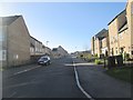
6
New Housing Development - Long Hill Road
Image: © Betty Longbottom
Taken: 18 Aug 2008
0.08 miles
7
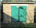
Electricity Substation No 322 - Bradley Boulevard
Image: © Betty Longbottom
Taken: 5 Nov 2014
0.09 miles
9

Suburban Redevelopment; Huddersfield
The now almost totally lifeless Brackenhall Estate steadily makes way for the newbuilding Ferndale development.
Image: © Ian M
Taken: 9 Jul 2005
0.09 miles
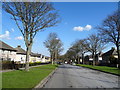
10
New House Road, Sheepridge, Fartown, Huddersfield
This road starts at the Sheepridge Road end as Wiggan Lane, but that branches off to the right and the name becomes New House Road. This was formerly New House Lane, and the old route turns off to the right as a footpath just before the buff-coloured houses on the right. New House Road continues to Bradley Boulevard at the bottom of the hill, and the school opposite is the 'Our Lady of Lourdes' RC Primary School.
Image: © Humphrey Bolton
Taken: 5 Mar 2007
0.09 miles