IMAGES TAKEN NEAR TO
Rordin Heights, HUDDERSFIELD, HD2 1GJ
Introduction
This page details the photographs taken nearby to Rordin Heights, HD2 1GJ by members of the Geograph project.
The Geograph project started in 2005 with the aim of publishing, organising and preserving representative images for every square kilometre of Great Britain, Ireland and the Isle of Man.

There are currently over 7.5m images from over14,400 individuals and you can help contribute to the project by visiting https://www.geograph.org.uk
Image Map
Images are licensed for reuse under creativecommons.org/licenses/by-sa/2.0
Notes
- Clicking on the map will re-center to the selected point.
- The higher the marker number, the further away the image location is from the centre of the postcode.
Image Listing (86 Images Found)
Images are licensed for reuse under creativecommons.org/licenses/by-sa/2.0
Image
Details
Distance
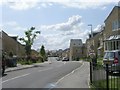
1
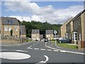
New houses and flats, Long Hill Road, Brackenhall, Fartown, Huddersfield
These replace council houses. Fortunately the speed humps are of the plateau type rather than the vicious pyramids.
Image: © Humphrey Bolton
Taken: 5 Mar 2007
0.01 miles
2
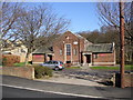
United Reformed Church, Long Hill Road, Brackenhall, Fartown, Huddersfield
This is also a community centre; it was built as a Congregational Chapel in the mid-20C to serve the council house estate that has been recently redeveloped. It was paid for by the proceeds of the sale to the Corporation of the old Ramsden Street Congregational Chapel (closed in 1933) site on which the Central Library was built.
Image: © Humphrey Bolton
Taken: 5 Mar 2007
0.01 miles
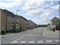
4
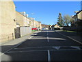
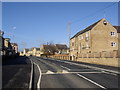
Robin Hood Road - viewed from Rordin Heights
Image: © Betty Longbottom
Taken: 5 Nov 2014
0.02 miles
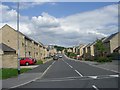
5
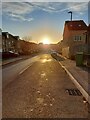
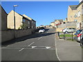
Robin Hood Road, just before sunset in winter
Image: © yorkshirelad
Taken: 15 Dec 2021
0.03 miles