IMAGES TAKEN NEAR TO
St. Andrews Road, HUDDERSFIELD, HD1 6RZ
Introduction
This page details the photographs taken nearby to St. Andrews Road, HD1 6RZ by members of the Geograph project.
The Geograph project started in 2005 with the aim of publishing, organising and preserving representative images for every square kilometre of Great Britain, Ireland and the Isle of Man.

There are currently over 7.5m images from over14,400 individuals and you can help contribute to the project by visiting https://www.geograph.org.uk
Image Map
Images are licensed for reuse under creativecommons.org/licenses/by-sa/2.0
Notes
- Clicking on the map will re-center to the selected point.
- The higher the marker number, the further away the image location is from the centre of the postcode.
Image Listing (166 Images Found)
Images are licensed for reuse under creativecommons.org/licenses/by-sa/2.0
Image
Details
Distance
1
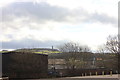
At the end of the carpark
Industrial buildings at the edge of the large open space filled with cars on HTAFC match days to my knowledge - other times I know not. A distant view of Castle Hill which defines views around Huddersfield, as Jodrell Bank does in Cheshire.
Image: © Peter Turner
Taken: 10 Mar 2012
0.06 miles
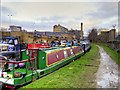
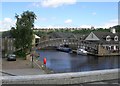
3
Canal path, Huddersfield
A towpath alongside the Huddersfield Broad Canal.
Image: © Malc McDonald
Taken: 12 Jun 2021
0.07 miles
5
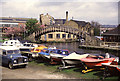
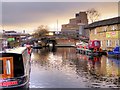
Aspley Basin, Huddersfield
A very similar view to that of Stanley Walker Image
Image: © Chris Allen
Taken: 1 May 1988
0.07 miles
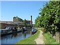
6
Huddersfield Broad Canal
Looking from Aspley Basin with the Quay Street Locomotive Lifting Bridge in the distance.Image
Image: © Stephen Armstrong
Taken: 24 Nov 2010
0.07 miles
7
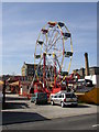
Easter fair, St Andrew's Road, Huddersfield
This is on a car park for the engineering works opposite. The site contained several streets of terrace houses until the mid-20C.
Image: © Humphrey Bolton
Taken: 5 Apr 2007
0.08 miles
8
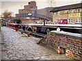
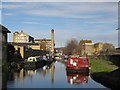
Huddersfield Broad Canal, Aspley Wharf
For over 150 years, Aspley Basin was one of the busiest places in Huddersfield. It came into being when the Broad Canal was completed and greatly increased in importance once the Narrow Canal was finished in 1811. The site was laid out with wharves, cranes and housing for canal workers creating a small dockland. It was a flourishing place because goods had to be transhipped here from the Broad Canal barges to narrowboats and vice versa as the barges were too wide to use the Narrow Canal and the narrowboats were too long to pass through the short locks on the Broad Canal. Today, the basin has been made into a small marina.
The tall, red building in the background is the University of Huddersfield's Central Services Building.
Image: © David Dixon
Taken: 5 Jan 2015
0.08 miles
9
Aspley Basin, Huddersfield Broad Canal
For over 150 years, Aspley Basin was one of the busiest places in Huddersfield. It came into being when the Broad Canal was completed and greatly increased in importance once the Narrow Canal was finished in 1811. The site was laid out with wharves, cranes and housing for canal workers creating a small dockland. It was a flourishing place because goods had to be transhipped here from the Broad Canal barges to narrowboats and vice versa as the barges were too wide to use the Narrow Canal and the narrowboats were too long to pass through the short locks on the Broad Canal. Today, the basin has been made into a small marina.
Image: © David Dixon
Taken: 5 Jan 2015
0.08 miles
10
Footbridge over Huddersfield Broad Canal - Wakefield Road
Image: © Betty Longbottom
Taken: 19 Jul 2008
0.09 miles