IMAGES TAKEN NEAR TO
St. Andrews Road, HUDDERSFIELD, HD1 6PT
Introduction
This page details the photographs taken nearby to St. Andrews Road, HD1 6PT by members of the Geograph project.
The Geograph project started in 2005 with the aim of publishing, organising and preserving representative images for every square kilometre of Great Britain, Ireland and the Isle of Man.

There are currently over 7.5m images from over14,400 individuals and you can help contribute to the project by visiting https://www.geograph.org.uk
Image Map
Images are licensed for reuse under creativecommons.org/licenses/by-sa/2.0
Notes
- Clicking on the map will re-center to the selected point.
- The higher the marker number, the further away the image location is from the centre of the postcode.
Image Listing (107 Images Found)
Images are licensed for reuse under creativecommons.org/licenses/by-sa/2.0
Image
Details
Distance
1
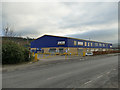
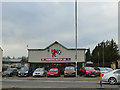
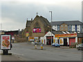
Jewson, St Andrew's Road, Huddersfield
A branch of a national chain of builders merchants.
Image: © Stephen Craven
Taken: 25 Jan 2020
0.01 miles
2
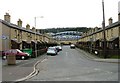
Town Terrace - Leeds Road
This view shows the Galpharm Stadium in the background.
Image: © Betty Longbottom
Taken: 9 Apr 2008
0.03 miles
3
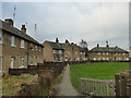
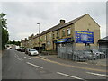
Houses on St Andrew's Road, Huddersfield
A crescent of houses of possibly 1940s/50s age, in what is a mainly industrial part of town.
Image: © Stephen Craven
Taken: 25 Jan 2020
0.04 miles
4
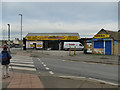
Zebra crossing, St Andrew's Road, Huddersfield
At the Leeds Road end of a road that was named after a nearby church Image
Image: © Stephen Craven
Taken: 25 Jan 2020
0.06 miles
5
Thistle Street, Huddersfield
Thistle Street in Huddersfield.
Image: © Malc McDonald
Taken: 14 Jun 2021
0.08 miles
6
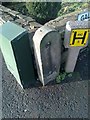
Old Boundary Marker by the A62, Leeds Road, Huddersfield Parish
Parish Boundary Marker in parish of Huddersfield (Kirklees District), Leeds Road Bradley Mills, at corner with Galloway Street, against wall.
Surveyed
Milestone Society National ID: YW_HIB04pb
Image: © Milestone Society
Taken: Unknown
0.09 miles
7
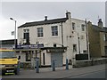
St Andrew's Motor Co., Leeds Road, Huddersfield
Named after a nearby church Image
Image: © Stephen Craven
Taken: 25 Jan 2020
0.09 miles
8
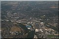
Huddersfield north, Bradley Mills and John Smith's Stadium: aerial 2018
Image: © Chris
Taken: 2 Jul 2018
0.09 miles
9
Former St Andrew's church, Leeds Road, Huddersfield
The church was built in 1870, architect W.H. Crossland of Leeds. It was declared redundant in 1975, and listed grade II after closure (current list entry 1214957). Initially sold, along with the adjacent site of the now-demolished church school, to the Roman Catholics, following a fire the building was sold again in 2003 and permission was granted in 2007 for conversion to office or retail use, but it appears still to be disused.
Image: © Stephen Craven
Taken: 25 Jan 2020
0.10 miles
10
Bradley Mills School WMC - Leeds Road
Image: © Betty Longbottom
Taken: 9 Apr 2008
0.11 miles