1
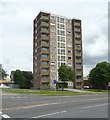
Harold Wilson House, Leeds Road, Huddersfield
You might expect that the former Prime Minister's name would be attached to the Labour Party headquarters in the town, or some major civic building. In fact, it's just a 11-storey block of flats by the ring road.
Image: © Stephen Craven
Taken: 25 Jan 2020
0.01 miles
2
Harold Wilson House
The resurfaced Harold Wilson house, done after and I think, in response to, the Grenfell fire. The two mills in the background are John L Brierley and sited next to the Huddersfield Broad canal.
This image was taken just as the roadworks and new junction had been constructed at the top of Leeds Road - where the traffic lights are.
Image: © Terry
Taken: 27 May 2023
0.01 miles
3
611 Centre, Southgate
This is a recently opened Pregnancy Advice Centre with unmistakable connections to a local church group. There used to be another one with different associations in a different part of town but apparently that closed its doors some time ago. This is one of a number of centres across the UK where women with concerns over unwelcome pregnancies (suspected or confirmed) can obtain advice and support, but not a referral for abortion.
Image: © David Ward
Taken: 30 Jul 2007
0.02 miles
4
View from a hill
Looking across Huddersfield towards the university. In the foreground is the railway viaduct across Bradford Road which takes the line into the railway station, beyond that is the only one of what used to be three high rise flats buildings. Where the white 'stick' shape is in the centre of the photograph is where the new medical faculty for the university will be, the white 'stick' is one of the cranes being used to drive the piles in for the foundations.
Image: © Terry
Taken: 8 May 2023
0.04 miles
5
The Media Centre
Offices for creative, digital and media businesses in central Huddersfield.
Image: © Graham Hogg
Taken: 24 Jul 2013
0.04 miles
6
Huddersfield Open Market
The open part of Huddersfield market, trading having finished for the day, at the lower end of Brook Street.
Image: © David Ward
Taken: 27 Jul 2007
0.04 miles
7
Huddersfield Market
Image: © David Ward
Taken: 27 Jul 2007
0.05 miles
8
Huddersfield Covered Market
The Huddersfield covered market, trading ended for the day, in Lord Street with Brook Street in background.
Image: © David Ward
Taken: 27 Jul 2007
0.05 miles
9
Richmond Flats, Leeds Road A62, Huddersfield
One of three blocks providing homes on the fringe of the town centre.
Image: © Humphrey Bolton
Taken: 23 Jun 2008
0.06 miles
10
Tunnel Exit, Ring Road, Huddersfield
Of all the junctions on the Huddersfield Ring Road, just two were given partial grade separation. This one is a one-way tunnel starting under the railway viaduct, part of which can be seen in the distance, and emerging just short of the Leeds Road traffic lights having crossed under Bradford Road.
Image: © Humphrey Bolton
Taken: 23 Jun 2008
0.06 miles


