IMAGES TAKEN NEAR TO
Diamond Street, HUDDERSFIELD, HD1 6BZ
Introduction
This page details the photographs taken nearby to Diamond Street, HD1 6BZ by members of the Geograph project.
The Geograph project started in 2005 with the aim of publishing, organising and preserving representative images for every square kilometre of Great Britain, Ireland and the Isle of Man.

There are currently over 7.5m images from over14,400 individuals and you can help contribute to the project by visiting https://www.geograph.org.uk
Image Map
Images are licensed for reuse under creativecommons.org/licenses/by-sa/2.0
Notes
- Clicking on the map will re-center to the selected point.
- The higher the marker number, the further away the image location is from the centre of the postcode.
Image Listing (143 Images Found)
Images are licensed for reuse under creativecommons.org/licenses/by-sa/2.0
Image
Details
Distance
1
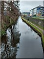
Hillhouse Lane, Huddersfield Broad Canal
Image: © yorkshirelad
Taken: 10 Jan 2021
0.04 miles
2
Retaining walls alongside the Huddersfield Broad Canal
The brick wall looks to be an old one, which over the years has had to be restrained with both ground anchors and brick buttresses. Nearer the camera is a more modern style gabion wall.
Image: © Stephen Craven
Taken: 25 Jan 2020
0.04 miles

5
Hillhouse Lane - viewed from Great Northern Street
Image: © Betty Longbottom
Taken: 18 Aug 2015
0.05 miles
6
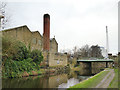
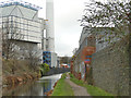
Old and new chimneys
The brick chimney belonged to a 20th century factory, and the taller one in the distance is at the 1990s waste-to-energy plant.
Image: © Stephen Craven
Taken: 25 Jan 2020
0.05 miles
7
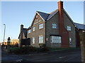
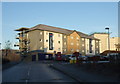
The Yorkshire Rose, Huddersfield
Near Travelodge Huddersfield Hotel.
Image: © JThomas
Taken: 6 Dec 2014
0.06 miles
8
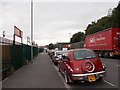
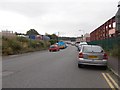
Great Northern Street - Hillhouse Lane
Image: © Betty Longbottom
Taken: 18 Aug 2015
0.06 miles
9
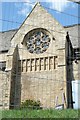
Detail of St Andrew's Church, Leeds Road A62, Fartown, Huddersfield
This is the transept gable and window of the former St Andrew's Anglican church in a site being redeveloped.
Image: © Humphrey Bolton
Taken: 17 Apr 2008
0.07 miles
10
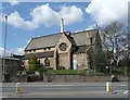
Disused church, Leeds Road A62, Fartown, Huddersfield
The former St Andrew's Anglican church is in a site, including a former chemical factory, that is currently being redeveloped.
The church was built in 1870, designed by W.H. Crossland of Leeds. It was declared redundant in 1975, after which it was used by a local Roman-Catholic congregation until c.2001.
More detail in http://list.english-heritage.org.uk/resultsingle.aspx?uid=1214957&searchtype=mapsearch
Photographs in http://www.28dayslater.co.uk/forums/showthread.php?t=22290
and http://www.urbexforums.co.uk/showthread.php/13591-St-Andrews-Church-Huddersfield-West-Yorkshire-30-05-2011
Image: © Humphrey Bolton
Taken: 17 Apr 2008
0.07 miles