IMAGES TAKEN NEAR TO
Mountjoy Road, HUDDERSFIELD, HD1 5QQ
Introduction
This page details the photographs taken nearby to Mountjoy Road, HD1 5QQ by members of the Geograph project.
The Geograph project started in 2005 with the aim of publishing, organising and preserving representative images for every square kilometre of Great Britain, Ireland and the Isle of Man.

There are currently over 7.5m images from over14,400 individuals and you can help contribute to the project by visiting https://www.geograph.org.uk
Image Map
Images are licensed for reuse under creativecommons.org/licenses/by-sa/2.0
Notes
- Clicking on the map will re-center to the selected point.
- The higher the marker number, the further away the image location is from the centre of the postcode.
Image Listing (114 Images Found)
Images are licensed for reuse under creativecommons.org/licenses/by-sa/2.0
Image
Details
Distance
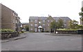
2
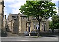
Trinity Street- Mountjoy Road, Huddersfield
Image: © Alex McGregor
Taken: 13 Dec 2010
0.04 miles
3
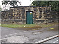
Electricity Substation No 217 - Mountjoy Road
Image: © Betty Longbottom
Taken: 24 Aug 2015
0.06 miles
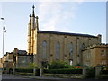
5
Wesleyan Sunday School - Edgerton Grove Road
Image: © Betty Longbottom
Taken: 13 May 2008
0.07 miles
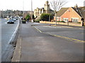
6
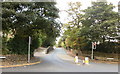
Edgerton Grove Road, Huddersfield
Viewed from where the A629 New North Road becomes the A629 Edgerton Road.
Image: © Jaggery
Taken: 26 Sep 2009
0.07 miles
8
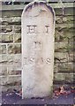
Old Boundary Marker by the A640, Trinity Street, Huddersfield
Parish Boundary Marker by the A640, in parish of Huddersfield (Kirklees District), Trinity Street; outside No. 163 (Antilles Credit Union), near corner with Cedar Street, back to wall.
Inscription reads:-
H.I.
P
18(4)8
Grade II listed.
List Entry Number: 1267584 https://historicengland.org.uk/listing/the-list/list-entry/1267584
Surveyed
Milestone Society National ID: YW_HIB01pb
Image: © Milestone Society
Taken: Unknown
0.09 miles
9
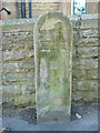
Huddersfield Improvement Act boundary stone, Trinity Street
The 1850 six-inch map shows the initail boundary of the area as a circle, ignoring topographical features, and this stone seems to be on this circle and is dated 1848. The early 1:2500 maps, from 1889 show a rather different detailed hatched-line boundary that follows property boundaries. I believe that this is a later Improvement Act boundary, but it is not explained in the key.
Image: © Humphrey Bolton
Taken: 6 Jun 2013
0.09 miles
10
Location of Huddersfield Improvement Act boundary stone, Trinity Street
See Image
Image: © Humphrey Bolton
Taken: 6 Jun 2013
0.09 miles