1
Ordnance Survey Cut Mark
This mark can be found on the roadside wall of 140 Fitzwilliam Street, Huddersfield.
The recorded details give a height of 121.7249 metres above sea level.
For more detail see : https://www.bench-marks.org.uk/bm78303
Image: © Peter Wood
Taken: 3 Jul 2022
0.04 miles
2
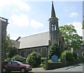
Chapel, Waverley Street, off New North Road, Huddersfield
Typical late 19C design, but built after 1907. I have not been able to find out the denomination.
Image: © Humphrey Bolton
Taken: 8 Jun 2007
0.04 miles
3
Waverley United Reformed Church - Waverley Road
Image: © Betty Longbottom
Taken: 13 May 2008
0.04 miles
4
Waverley United Reformed Church, Huddersfield
This URC is located in Waverley Road, and the building just to the east also belongs to the church.
Image: © Peter Church
Taken: 6 Mar 2010
0.04 miles
5
Waverley United Reformed Church
Image: © Alex McGregor
Taken: 7 Nov 2013
0.04 miles
6
Waverley United Reformed Church
Portland Street, Huddersfield.
Image: © Ian S
Taken: 25 Apr 2018
0.05 miles
7
J Block, Huddersfield College
This building is tucked into the north western corner of the grid square, and speaks of a 1960s heritage.
Image: © Peter Church
Taken: 6 Mar 2010
0.06 miles
8
Park gates, Greenhead Park
Image: © JThomas
Taken: 14 Mar 2015
0.06 miles
9
Gatehouse, Greenhead Park
Image: © JThomas
Taken: 14 Mar 2015
0.07 miles
10
Former infirmary. latterly a college, Huddersfield
This fine building in the classical style is now disused. The architect was John Oates and the infirmary on New North Road opened in 1831. It cost £7500 as built and had 20 beds initially. Like many building in Huddersfield it was built by the firm of Joseph Kaye. I believe I was born here and was certainly an inpatient once. It was replaced by a rather large and brutal building in Lindley that is visible from across the Colne Valley.
Image: © Chris Allen
Taken: 2 Nov 2017
0.08 miles


