1
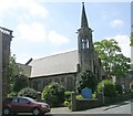
Chapel, Waverley Street, off New North Road, Huddersfield
Typical late 19C design, but built after 1907. I have not been able to find out the denomination.
Image: © Humphrey Bolton
Taken: 8 Jun 2007
0.02 miles
2
Waverley United Reformed Church - Waverley Road
Image: © Betty Longbottom
Taken: 13 May 2008
0.02 miles
3
Waverley United Reformed Church, Huddersfield
This URC is located in Waverley Road, and the building just to the east also belongs to the church.
Image: © Peter Church
Taken: 6 Mar 2010
0.03 miles
4
Waverley United Reformed Church
Image: © Alex McGregor
Taken: 7 Nov 2013
0.03 miles
5
Waverley United Reformed Church
Portland Street, Huddersfield.
Image: © Ian S
Taken: 25 Apr 2018
0.04 miles
6
Ordnance Survey Cut Mark
This mark can be found on the roadside wall of 140 Fitzwilliam Street, Huddersfield.
The recorded details give a height of 121.7249 metres above sea level.
For more detail see : https://www.bench-marks.org.uk/bm78303
Image: © Peter Wood
Taken: 3 Jul 2022
0.04 miles
7
J Block, Huddersfield College
This building is tucked into the north western corner of the grid square, and speaks of a 1960s heritage.
Image: © Peter Church
Taken: 6 Mar 2010
0.06 miles
8
Park gates, Greenhead Park
Image: © JThomas
Taken: 14 Mar 2015
0.07 miles
9
Waverley Hall, Waverley Street, off New North Road, Huddersfield
Built probably in the first half of the 20C. Looks to be now a house, but still has the 'Waverley Hall' sign and is apparently the Huddersfield Freedom Christian Centre.
Image: © Humphrey Bolton
Taken: 8 Jun 2007
0.08 miles
10
Ordnance Survey Cut Mark with Pivot
This can be found on the wall of a house in Wentworth Street, Huddersfield.
The recorded details give a height of 123.8372 metres above sea level.
For more detail see : https://www.bench-marks.org.uk/bm175455
Image: © Peter Wood
Taken: 3 Jul 2022
0.08 miles


