IMAGES TAKEN NEAR TO
Portland Street, HUDDERSFIELD, HD1 5PL
Introduction
This page details the photographs taken nearby to Portland Street, HD1 5PL by members of the Geograph project.
The Geograph project started in 2005 with the aim of publishing, organising and preserving representative images for every square kilometre of Great Britain, Ireland and the Isle of Man.

There are currently over 7.5m images from over14,400 individuals and you can help contribute to the project by visiting https://www.geograph.org.uk
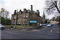
Image Map (Loading...)


Getting Data...Please wait
Leaflet Map data © OpenStreetMap
Images are licensed for reuse under creativecommons.org/licenses/by-sa/2.0
Notes
- Clicking on the map will re-center to the selected point.
- The higher the marker number, the further away the image location is from the centre of the postcode.
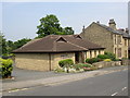
Image Listing (274 Images Found)
Images are licensed for reuse under creativecommons.org/licenses/by-sa/2.0
Image
Details
Distance
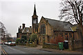
1
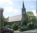
Waverley United Reformed Church
Portland Street, Huddersfield.
Image: © Ian S
Taken: 25 Apr 2018
0.02 miles
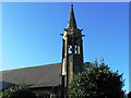
2
Waverley United Reformed Church, Huddersfield
This URC is located in Waverley Road, and the building just to the east also belongs to the church.
Image: © Peter Church
Taken: 6 Mar 2010
0.03 miles
4
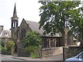
Chapel, Waverley Street, off New North Road, Huddersfield
Typical late 19C design, but built after 1907. I have not been able to find out the denomination.
Image: © Humphrey Bolton
Taken: 8 Jun 2007
0.04 miles
5
Waverley United Reformed Church - Waverley Road
Image: © Betty Longbottom
Taken: 13 May 2008
0.04 miles
6
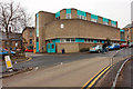
J Block, Huddersfield College
This building is tucked into the north western corner of the grid square, and speaks of a 1960s heritage.
Image: © Peter Church
Taken: 6 Mar 2010
0.04 miles
7
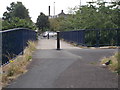
Footbridge over Castlegate Sliproad
Image: © Betty Longbottom
Taken: 18 Aug 2015
0.06 miles
8
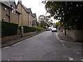
Belgrave Terrace - Highfields Road
Image: © Betty Longbottom
Taken: 18 Aug 2015
0.07 miles
9
Kingdom Hall, Belmont Street, Huddersfield
Like Quaker meeting houses, these are not generally shown on OS maps as 'places of worship'.
Image: © Humphrey Bolton
Taken: 8 Jun 2007
0.07 miles
10

Ordnance Survey Cut Mark
This mark can be found on the roadside wall of 140 Fitzwilliam Street, Huddersfield.
The recorded details give a height of 121.7249 metres above sea level.
For more detail see : https://www.bench-marks.org.uk/bm78303
Image: © Peter Wood
Taken: 3 Jul 2022
0.07 miles