IMAGES TAKEN NEAR TO
Blacker Road, HUDDERSFIELD, HD1 5HU
Introduction
This page details the photographs taken nearby to Blacker Road, HD1 5HU by members of the Geograph project.
The Geograph project started in 2005 with the aim of publishing, organising and preserving representative images for every square kilometre of Great Britain, Ireland and the Isle of Man.

There are currently over 7.5m images from over14,400 individuals and you can help contribute to the project by visiting https://www.geograph.org.uk
Image Map
Images are licensed for reuse under creativecommons.org/licenses/by-sa/2.0
Notes
- Clicking on the map will re-center to the selected point.
- The higher the marker number, the further away the image location is from the centre of the postcode.
Image Listing (123 Images Found)
Images are licensed for reuse under creativecommons.org/licenses/by-sa/2.0
Image
Details
Distance
1
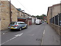
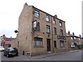
Filbert Street - Bay Hall Common Road
Image: © Betty Longbottom
Taken: 18 Aug 2015
0.01 miles
4
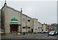
Masjid Omar, Blacker Road, Birkby, Huddersfield
Image: © habiloid
Taken: 13 Feb 2023
0.02 miles
5
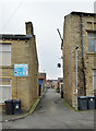
An alley off Bay Hall Common Road, Birkby, Huddersfield
Image: © habiloid
Taken: 13 Feb 2023
0.02 miles
6

Arnold Street - Blacker Road North
Image: © Betty Longbottom
Taken: 18 Aug 2015
0.05 miles
8
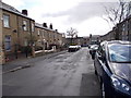
Arnold Street - viewed from Sufton Street
Image: © Betty Longbottom
Taken: 31 Mar 2015
0.06 miles
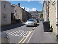
9
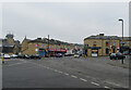
The junction of Blacker Road, Crescent Road and Norman Road, Birkby, Huddersfield
Image: © habiloid
Taken: 13 Feb 2023
0.06 miles
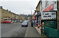
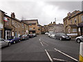
10
Armitage Arms - Bay Hall Common Road
Image: © Betty Longbottom
Taken: 18 Aug 2015
0.06 miles