IMAGES TAKEN NEAR TO
Elmwood Avenue, HUDDERSFIELD, HD1 5DA
Introduction
This page details the photographs taken nearby to Elmwood Avenue, HD1 5DA by members of the Geograph project.
The Geograph project started in 2005 with the aim of publishing, organising and preserving representative images for every square kilometre of Great Britain, Ireland and the Isle of Man.

There are currently over 7.5m images from over14,400 individuals and you can help contribute to the project by visiting https://www.geograph.org.uk
Image Map
Images are licensed for reuse under creativecommons.org/licenses/by-sa/2.0
Notes
- Clicking on the map will re-center to the selected point.
- The higher the marker number, the further away the image location is from the centre of the postcode.
Image Listing (376 Images Found)
Images are licensed for reuse under creativecommons.org/licenses/by-sa/2.0
Image
Details
Distance
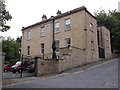
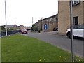
1
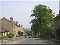
Belmont Street, Huddersfield
Terrace houses on the northern fringe of the town centre.
Image: © Humphrey Bolton
Taken: 8 Jun 2007
0.01 miles
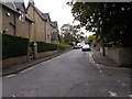
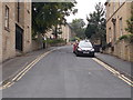
2
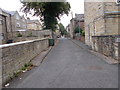
Elmwood Close - looking towards Elmwood Avenue
Image: © Betty Longbottom
Taken: 18 Aug 2015
0.03 miles
4
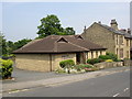
Kingdom Hall, Belmont Street, Huddersfield
Like Quaker meeting houses, these are not generally shown on OS maps as 'places of worship'.
Image: © Humphrey Bolton
Taken: 8 Jun 2007
0.05 miles
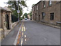
5
Belgrave Terrace - Highfields Road
Image: © Betty Longbottom
Taken: 18 Aug 2015
0.06 miles
6
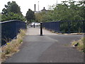
Footbridge over Castlegate Sliproad
Image: © Betty Longbottom
Taken: 18 Aug 2015
0.06 miles
8
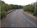
Castlegate - viewed from Fitzwilliam Street Bridge
Image: © Betty Longbottom
Taken: 18 Aug 2015
0.06 miles
10
Little Brunswick Street - Fitzwilliam Street
Image: © Betty Longbottom
Taken: 18 Aug 2015
0.07 miles