IMAGES TAKEN NEAR TO
The Nab, HUDDERSFIELD, HD1 4UF
Introduction
This page details the photographs taken nearby to The Nab, HD1 4UF by members of the Geograph project.
The Geograph project started in 2005 with the aim of publishing, organising and preserving representative images for every square kilometre of Great Britain, Ireland and the Isle of Man.

There are currently over 7.5m images from over14,400 individuals and you can help contribute to the project by visiting https://www.geograph.org.uk
Image Map
Images are licensed for reuse under creativecommons.org/licenses/by-sa/2.0
Notes
- Clicking on the map will re-center to the selected point.
- The higher the marker number, the further away the image location is from the centre of the postcode.
Image Listing (103 Images Found)
Images are licensed for reuse under creativecommons.org/licenses/by-sa/2.0
Image
Details
Distance
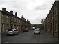
3
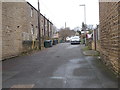
South Street, off Church Street, Paddock, Marsh
This street is brightened up by floral baskets.
Image: © Humphrey Bolton
Taken: 12 Jul 2007
0.04 miles
6
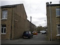
Croft Street, Paddock
Off South Street.
Image: © Richard Vince
Taken: 10 Apr 2019
0.05 miles
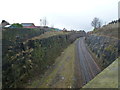
9
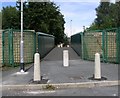
Bridge MVL3-81 - Clough Lane, Paddock
Image: © Betty Longbottom
Taken: 13 Aug 2008
0.06 miles
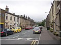
10
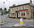
The Royal Oak, Church Street, Paddock, Marsh
At the top end of Church Street. The roundabout here marks the boundary of Marsh
Image: © Humphrey Bolton
Taken: 12 Jul 2007
0.07 miles