IMAGES TAKEN NEAR TO
New Street, HUDDERSFIELD, HD1 4SP
Introduction
This page details the photographs taken nearby to New Street, HD1 4SP by members of the Geograph project.
The Geograph project started in 2005 with the aim of publishing, organising and preserving representative images for every square kilometre of Great Britain, Ireland and the Isle of Man.

There are currently over 7.5m images from over14,400 individuals and you can help contribute to the project by visiting https://www.geograph.org.uk
Image Map (Loading...)


Getting Data...Please wait
Leaflet Map data © OpenStreetMap
Images are licensed for reuse under creativecommons.org/licenses/by-sa/2.0
Notes
- Clicking on the map will re-center to the selected point.
- The higher the marker number, the further away the image location is from the centre of the postcode.
Image Listing (105 Images Found)
Images are licensed for reuse under creativecommons.org/licenses/by-sa/2.0
Image
Details
Distance
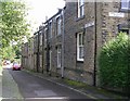

3
Terraced Houses, Huddersfield
A short street of terraced houses in the Paddock area of Huddersfield.
Image: © David Robinson
Taken: 17 Aug 2019
0.05 miles
4
Church Street / Market Street, Paddock, Marsh (Huddersfield)
This road was called 'Paddock Road' on the 1850 map, but now changes its name at the road junction with Brow Road (on the right). Most of the 19C buildings survive.
Image: © Humphrey Bolton
Taken: 10 Sep 2006
0.06 miles
5
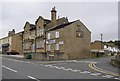
High Street, Paddock, Marsh (Huddersfield)
From the name, I suspect that this was the original village street of Paddock. Not many old buildings are left.
Image: © Humphrey Bolton
Taken: 10 Sep 2006
0.06 miles
6
The Ship, Market Street, Paddock, Marsh
Yet another public house vacant and awaiting a new tenant.
Image: © Humphrey Bolton
Taken: 12 Jul 2007
0.06 miles
7
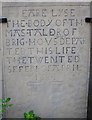
Gravestone in the porch of the Quaker Meeting House, Paddock, Marsh (Huddersfield)
This was carved before the spelling of English words was standardised by the publication of cheap dictionaries. However Taler was corrected to Talor, but the missing 'Y' was not corrected. 'WHO' has been inserted as an afterthought, although perhaps a comma would have been sufficient.
Image: © Humphrey Bolton
Taken: 10 Sep 2006
0.08 miles
8
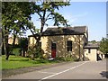
Friends' (Quaker) Meeting House, Paddock, Marsh (Huddersfield)
The meeting house proper is the one at the front, built in 1770. The central door is a recent addition due to fire regulations; there was originally just a window there. Although a place of worship, it is not indicated as such on the OS map. An Adult School was established in 1798, and the building at the rear added in 1898. This provides rooms for the local community to hire for various purposes.
Image: © Humphrey Bolton
Taken: 10 Sep 2006
0.08 miles
9
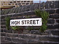
Street nameplate with ferns, New Street / High Street, Paddock, Marsh (Huddersfield)
For some reason this nameplate has provided a better micro-climate for the ferns than the adjacent parts of the wall.
Image: © Humphrey Bolton
Taken: 10 Sep 2006
0.08 miles
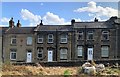
10
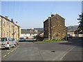
New Street and High Street, Paddock, Marsh (Huddersfield)
New Street is on the left, and originally extended across where the modern houses are. It was not there in 1850, but High Street was, and the pair of houses in the centre are probably survivals from the early 19C.
Image: © Humphrey Bolton
Taken: 10 Sep 2006
0.08 miles