IMAGES TAKEN NEAR TO
Abb Street, HUDDERSFIELD, HD1 4PB
Introduction
This page details the photographs taken nearby to Abb Street, HD1 4PB by members of the Geograph project.
The Geograph project started in 2005 with the aim of publishing, organising and preserving representative images for every square kilometre of Great Britain, Ireland and the Isle of Man.

There are currently over 7.5m images from over14,400 individuals and you can help contribute to the project by visiting https://www.geograph.org.uk
Image Map
Images are licensed for reuse under creativecommons.org/licenses/by-sa/2.0
Notes
- Clicking on the map will re-center to the selected point.
- The higher the marker number, the further away the image location is from the centre of the postcode.
Image Listing (112 Images Found)
Images are licensed for reuse under creativecommons.org/licenses/by-sa/2.0
Image
Details
Distance
1
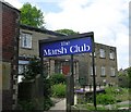
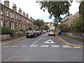
The Marsh Club - Abb Street , Westbourne Road
Image: © Betty Longbottom
Taken: 13 May 2008
0.02 miles
7
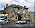
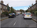
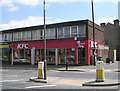
The junction of Westbourne Road (A640) and Croft House Lane, Marsh, Huddersfield
Image: © habiloid
Taken: 7 Sep 2023
0.07 miles
8
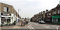
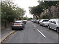
Westbourne Road (A640), Marsh, Huddersfield
Image: © habiloid
Taken: 7 Sep 2023
0.07 miles
10
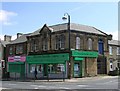
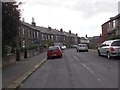
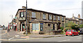
No 11 Branch - Huddersfield Industrial Society - Westbourne Road
This is now a shop selling material etc.
Image: © Betty Longbottom
Taken: 13 May 2008
0.07 miles