IMAGES TAKEN NEAR TO
Gledholt Bank, HUDDERSFIELD, HD1 4HE
Introduction
This page details the photographs taken nearby to Gledholt Bank, HD1 4HE by members of the Geograph project.
The Geograph project started in 2005 with the aim of publishing, organising and preserving representative images for every square kilometre of Great Britain, Ireland and the Isle of Man.

There are currently over 7.5m images from over14,400 individuals and you can help contribute to the project by visiting https://www.geograph.org.uk
Image Map
Images are licensed for reuse under creativecommons.org/licenses/by-sa/2.0
Notes
- Clicking on the map will re-center to the selected point.
- The higher the marker number, the further away the image location is from the centre of the postcode.
Image Listing (77 Images Found)
Images are licensed for reuse under creativecommons.org/licenses/by-sa/2.0
Image
Details
Distance
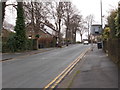
3
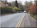
Gledholt Bank - viewed from Greenhead Road
Image: © Betty Longbottom
Taken: 2 Feb 2016
0.09 miles
5
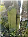
Old Boundary Marker by Greenhead Road, Huddersfield parish
Parish Boundary Marker in parish of Huddersfield (Kirklees District), Greenhead Road, Gledholt, against low wall.
Surveyed
Milestone Society National ID: YW_HIB05pb
Image: © Milestone Society
Taken: Unknown
0.10 miles
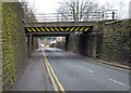
7
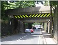
Bridge MVL3-85 - Gledholt Bank, Paddock
Image: © Betty Longbottom
Taken: 13 Aug 2008
0.12 miles
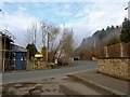
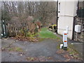
9
Gledholt Road - viewed from Greenhead Road
Image: © Betty Longbottom
Taken: 2 Feb 2016
0.12 miles
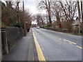
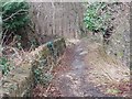
10
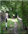
Springwood Footpath - Gledholt Bank, Paddock
Image: © Betty Longbottom
Taken: 13 Aug 2008
0.15 miles