IMAGES TAKEN NEAR TO
Spring Grove Street, HUDDERSFIELD, HD1 4BP
Introduction
This page details the photographs taken nearby to Spring Grove Street, HD1 4BP by members of the Geograph project.
The Geograph project started in 2005 with the aim of publishing, organising and preserving representative images for every square kilometre of Great Britain, Ireland and the Isle of Man.

There are currently over 7.5m images from over14,400 individuals and you can help contribute to the project by visiting https://www.geograph.org.uk
Image Map
Images are licensed for reuse under creativecommons.org/licenses/by-sa/2.0
Notes
- Clicking on the map will re-center to the selected point.
- The higher the marker number, the further away the image location is from the centre of the postcode.
Image Listing (240 Images Found)
Images are licensed for reuse under creativecommons.org/licenses/by-sa/2.0
Image
Details
Distance
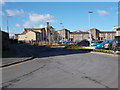
1
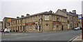
The Grove Public House, Merton Street, Huddersfield
This was apparently built as an L-shaped block with a pub at the corner and houses each side. The pub has absorbed at least one of the houses, judging by the blocked-up doorway. The original entrance on the corner has also been blocked.
Image: © Humphrey Bolton
Taken: 28 Jun 2006
0.03 miles
2
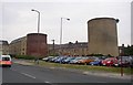
Tunnel shafts off Merton Street, Huddersfield
Massive ventilation shafts, one on each of the two parallel railway tunnels. Springwood Street used to be on the line of the tunnels, but much of it has disappeared under car parks and the ring road.
The following is a quotation from the Wikipedia article:
"The first section of the line, between Huddersfield and Stalybridge, was opened by the Manchester, Stockport and Leeds Railway on 1 August 1849."
Image: © Humphrey Bolton
Taken: 28 Jun 2006
0.03 miles
3
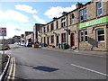
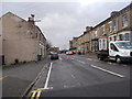
Spring Grove Street - Merton Street
Image: © Betty Longbottom
Taken: 25 Feb 2016
0.04 miles
4
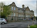
Spring Grove Primary School, Water Street, Huddersfield
Probably of late 19th century date.
Image: © Stephen Craven
Taken: 2 Oct 2022
0.05 miles
5
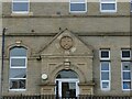
Spring Grove Primary School - detail
One of the original entrances, this one labelled 'Girls school'. See Image for context.
Image: © Stephen Craven
Taken: 2 Oct 2022
0.05 miles
6
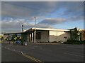
Huddersfield Leisure Centre, Merton Street
Built on an area formerly occupied by a road called South Street and the side streets of terraced housing either side of it, none of which now exists.
Image: © Stephen Craven
Taken: 2 Oct 2022
0.05 miles
7
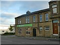
The Grove, Merton Street, Huddersfield
One of several real ale pubs in or on the edge of the town centre.
Image: © Stephen Craven
Taken: 2 Oct 2022
0.05 miles
10
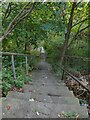
Steps down to Bankfield Road
The steps provide a link down the steep hillside for pedestrians from Bow Street.
Image: © Stephen Craven
Taken: 2 Oct 2022
0.07 miles