IMAGES TAKEN NEAR TO
Springwood Street, HUDDERSFIELD, HD1 4BE
Introduction
This page details the photographs taken nearby to Springwood Street, HD1 4BE by members of the Geograph project.
The Geograph project started in 2005 with the aim of publishing, organising and preserving representative images for every square kilometre of Great Britain, Ireland and the Isle of Man.

There are currently over 7.5m images from over14,400 individuals and you can help contribute to the project by visiting https://www.geograph.org.uk
Image Map
Images are licensed for reuse under creativecommons.org/licenses/by-sa/2.0
Notes
- Clicking on the map will re-center to the selected point.
- The higher the marker number, the further away the image location is from the centre of the postcode.
Image Listing (250 Images Found)
Images are licensed for reuse under creativecommons.org/licenses/by-sa/2.0
Image
Details
Distance
3
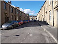
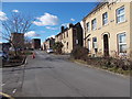
Back Cecil Street - Springwood Street
Image: © Betty Longbottom
Taken: 25 Feb 2016
0.03 miles
4
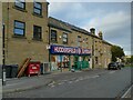
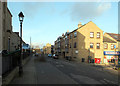
Huddersfield Supersave
A shop on Springwood Street.
Image: © Stephen Craven
Taken: 2 Oct 2022
0.03 miles
5
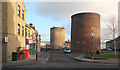
Ventilation Shafts, Springwood, Huddersfield
These ventilation shafts were built in the nineteenth century to service the railway tunnel running under here.
Image: © habiloid
Taken: 3 Jan 2020
0.03 miles
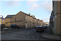
6
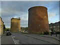
Air shafts on Springwood tunnels
Immediately south-west of Huddersfield station the railway goes into a pair of single-bore tunnels, each with one intermediate air shaft.
Image: © Stephen Craven
Taken: 2 Oct 2022
0.03 miles
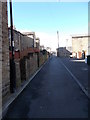
8
Springwood Street - viewed from Old South Street
Image: © Betty Longbottom
Taken: 25 Feb 2016
0.04 miles
9
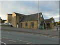
Elim Church, Merton Street, Huddersfield
The 'Huddersfield exposed' website shows an extract from the 1890 large scale (1:1500) map that labels this building 'Catholic Apostolic Church', and comments that it was already Elim Pentecostal by 1960. It's the only structure (apart from the tunnel vent shafts, one of them seen in the background) to have survived a wide area of demolition in the mid/late 20th century.
Image: © Stephen Craven
Taken: 2 Oct 2022
0.04 miles
10
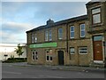
The Grove, Merton Street, Huddersfield
One of several real ale pubs in or on the edge of the town centre.
Image: © Stephen Craven
Taken: 2 Oct 2022
0.05 miles