IMAGES TAKEN NEAR TO
Victoria Road, HUDDERSFIELD, HD1 3TT
Introduction
This page details the photographs taken nearby to Victoria Road, HD1 3TT by members of the Geograph project.
The Geograph project started in 2005 with the aim of publishing, organising and preserving representative images for every square kilometre of Great Britain, Ireland and the Isle of Man.

There are currently over 7.5m images from over14,400 individuals and you can help contribute to the project by visiting https://www.geograph.org.uk
Image Map
Images are licensed for reuse under creativecommons.org/licenses/by-sa/2.0
Notes
- Clicking on the map will re-center to the selected point.
- The higher the marker number, the further away the image location is from the centre of the postcode.
Image Listing (259 Images Found)
Images are licensed for reuse under creativecommons.org/licenses/by-sa/2.0
Image
Details
Distance
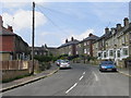
2
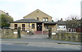
Lockwood & Salford Liberal Club - Victoria Road
Image: © Betty Longbottom
Taken: 28 Jun 2010
0.02 miles
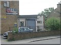
3
Lockwood and Salford Liberal Club, Victoria Road
The club premises were moved here from Royds House, which was captioned 'Club' on the 1905 1:2500 map. The present club premises were built on part of the grounds of North House.
Image: © Humphrey Bolton
Taken: 25 Mar 2015
0.02 miles

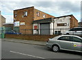
6
Connect Housing, North House, Lockwood
This building replaces a large old house. Connect Housing provide support and short-term hostel accommodation for young single people who are homeless, the victims of abuse, or otherwise in need of help.
Image: © Humphrey Bolton
Taken: 18 Mar 2015
0.04 miles
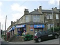
9
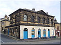
Town Hall
Lockwood just 2 miles West of Huddersfield was an Independent Township with a Local Governing Board formed in 1833 which held its meetings in the local School until the New Town Hall was opened in 1866 which was the first in the country built by such a body to provide itself with a Town Hall, however by 1869 Lockwood became part of the newly formed Huddersfield Corporation the building no longer required for meetings was used as a Police Station then a Fire Station and today it is now used by a local Ice Cream Maker.
Image: © Stanley Walker
Taken: 29 Jan 2007
0.05 miles
