IMAGES TAKEN NEAR TO
Bankfield Road, HUDDERSFIELD, HD1 3HR
Introduction
This page details the photographs taken nearby to Bankfield Road, HD1 3HR by members of the Geograph project.
The Geograph project started in 2005 with the aim of publishing, organising and preserving representative images for every square kilometre of Great Britain, Ireland and the Isle of Man.

There are currently over 7.5m images from over14,400 individuals and you can help contribute to the project by visiting https://www.geograph.org.uk
Image Map
Images are licensed for reuse under creativecommons.org/licenses/by-sa/2.0
Notes
- Clicking on the map will re-center to the selected point.
- The higher the marker number, the further away the image location is from the centre of the postcode.
Image Listing (184 Images Found)
Images are licensed for reuse under creativecommons.org/licenses/by-sa/2.0
Image
Details
Distance
1
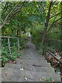
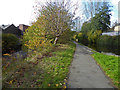
Steps down to Bankfield Road
The steps provide a link down the steep hillside for pedestrians from Bow Street.
Image: © Stephen Craven
Taken: 2 Oct 2022
0.01 miles
2
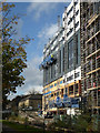
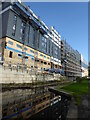
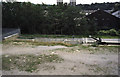
Construction site by the Huddersfield Narrow Canal
Until relatively recently this section of towpath was inaccessible between a tunnel and a fence. It was a pleasure to walk on a path that was new to me in an area I grew up in.
Image: © Chris Allen
Taken: 2 Nov 2017
0.06 miles
3
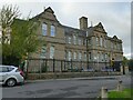
Spring Grove Primary School, Water Street, Huddersfield
Probably of late 19th century date.
Image: © Stephen Craven
Taken: 2 Oct 2022
0.06 miles
4
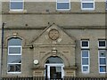
Spring Grove Primary School - detail
One of the original entrances, this one labelled 'Girls school'. See Image for context.
Image: © Stephen Craven
Taken: 2 Oct 2022
0.06 miles
5
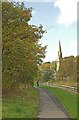
Canal walk, Huddersfield
The spire is that of the Grade II* listed Church of St Thomas, in Manchester Road. The church was built to the designs of architect George Gilbert Scott and is further described at this http://list.english-heritage.org.uk/resultsingle.aspx?uid=1134950.
Image: © Jim Osley
Taken: 17 Oct 2014
0.06 miles
6
Huddersfield Narrow Canal approaching Longroyd Bridge
I believe the construction may well be student accommodation. The canal at this point is narrow and there is a ladder descending into the water in the distance suggesting this was probably a lock. The restored canal had previously been in a long tunnel with a lock where it appeared into the open air. The canal has now been exposed for more of its length and the lock appears to have been moved closer to Chapel Hill.
Image: © Chris Allen
Taken: 2 Nov 2017
0.06 miles
7
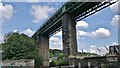
Railway bridge on line from Huddersfield to Penistone and Sheffield
Going over Huddersfield Narrow Canal
Image: © Chris Morgan
Taken: 24 Jul 2013
0.07 miles
8
Huddersfield Narrow Canal and River Colne
The canal and river are in reasonably close proximity along the Colne Valley and even swap sides via aqueducts at least twice. At this point it is possible to see the canal on the right and the river on the left. This part of the towpath was inaccessible for many years when the canal was derelict and behind a large mill. This was the first time I had ever walked this stretch, although I lived in Huddersfield for 18 years.
Image: © Chris Allen
Taken: 2 Nov 2017
0.07 miles
9
Huddersfield Narrow Canal from Manchester Road
Seen from the A62. This is where the canal emerges from a long tunnel under what was the works of Sellers Engineers. The company was to move to new premises in the spring of 2011 and a major waterfront redevelopment is to occur. This may see the canal re-exposed. Somebody please photograph this if it happens!
The canal was re-exposed and has been photographed - Image
Image: © Chris Allen
Taken: 17 Aug 2002
0.08 miles
10
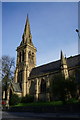
St Thomas Church
On Manchester Road, Huddersfield.
Image: © Ian S
Taken: 8 May 2015
0.08 miles