IMAGES TAKEN NEAR TO
Kings Bridge Road, HUDDERSFIELD, HD1 3DQ
Introduction
This page details the photographs taken nearby to Kings Bridge Road, HD1 3DQ by members of the Geograph project.
The Geograph project started in 2005 with the aim of publishing, organising and preserving representative images for every square kilometre of Great Britain, Ireland and the Isle of Man.

There are currently over 7.5m images from over14,400 individuals and you can help contribute to the project by visiting https://www.geograph.org.uk
Image Map
Images are licensed for reuse under creativecommons.org/licenses/by-sa/2.0
Notes
- Clicking on the map will re-center to the selected point.
- The higher the marker number, the further away the image location is from the centre of the postcode.
Image Listing (127 Images Found)
Images are licensed for reuse under creativecommons.org/licenses/by-sa/2.0
Image
Details
Distance
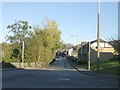
2
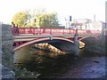
King's Bridge - viewed from King's Mill Lane
Image: © Betty Longbottom
Taken: 10 Nov 2010
0.04 miles
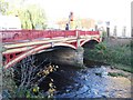
3
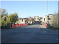
King's Bridge - King's Bridge Road
Image: © Betty Longbottom
Taken: 10 Nov 2010
0.05 miles
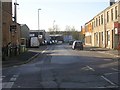
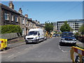
6
Colne Road - viewed from King's Bridge Road
Image: © Betty Longbottom
Taken: 24 May 2016
0.05 miles
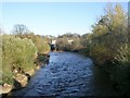
7
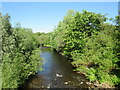
River Colne, Huddersfield
A view of the River Colne flowing through Huddersfield in West Yorkshire.
Image: © Malc McDonald
Taken: 12 Jun 2021
0.05 miles
9
River Colne - viewed from King's Bridge
Image: © Betty Longbottom
Taken: 10 Nov 2010
0.07 miles