IMAGES TAKEN NEAR TO
Firth Street, HUDDERSFIELD, HD1 3BL
Introduction
This page details the photographs taken nearby to Firth Street, HD1 3BL by members of the Geograph project.
The Geograph project started in 2005 with the aim of publishing, organising and preserving representative images for every square kilometre of Great Britain, Ireland and the Isle of Man.

There are currently over 7.5m images from over14,400 individuals and you can help contribute to the project by visiting https://www.geograph.org.uk
Image Map
Images are licensed for reuse under creativecommons.org/licenses/by-sa/2.0
Notes
- Clicking on the map will re-center to the selected point.
- The higher the marker number, the further away the image location is from the centre of the postcode.
Image Listing (237 Images Found)
Images are licensed for reuse under creativecommons.org/licenses/by-sa/2.0
Image
Details
Distance
2
University of Huddersfield, The Business School, Firth Street
Image: © Stephen Armstrong
Taken: 12 Sep 2010
0.02 miles
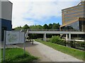
3
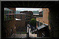
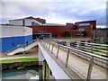
Walkway, University of Huddersfield
Looking from the upper ground level of the Central Services building near the library entrance towards the Firth Street building. There is a bridge taking the walkway over the Huddersfield Narrow Canal.
Image: © Mark Anderson
Taken: 6 Jun 2008
0.03 miles
5
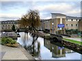
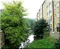
Huddersfield Broad Canal from Poly Bridge
A view looking north from the footbridge outside the University's Central Services Building. The section of the Huddersfield Broad Canal between Wakefield Road Bridge and Lock 1 of the Narrow Canal was restored and landscaped as part of the re-development of the area for the University. However, following strengthening work to Wakefield Road which included the construction of a reinforced concrete tunnel under the original bridge in the 1970s, this short section has been inaccessible from the rest of the Broad Canal and is only navigable to vessels whose width is less than 7 feet (narrowboats).
Image: © David Dixon
Taken: 5 Jan 2015
0.03 miles
6
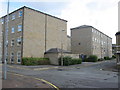
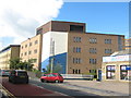
Firth Point Student Accommodation
The main entrance is on Firth Street. This is the rear of the complex on Colne Street.
Image: © Stephen Armstrong
Taken: 12 Sep 2010
0.03 miles
7
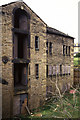
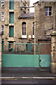
Derelict warehouse, Aspley
This is alongside the Huddersfield Narrow Canal as it leaves Aspley Basin. It is now barely recognisable as it has been converted in to flats.
Image: © Chris Allen
Taken: 1 May 1988
0.04 miles
8
Canal path, Huddersfield
A path alongside the Huddersfield Narrow Canal passing through the University of Huddersfield.
Image: © Malc McDonald
Taken: 13 Jun 2021
0.04 miles
9
Huddersfield University, Poly Bridge and The Business School
Footbridge connecting the Central Services Building with the Business School on the opposite side of the canal.
Image: © David Dixon
Taken: 5 Jan 2015
0.04 miles
10
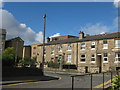
Firth Street Mills and engine house, Firth Street
This is Firth Street Mills. This was before the University converted it. The two tall windows indicate the position of an engine house. There used to be two chimneys here but the square one was dismantled piecemeal leaving the large stone one as a monument. The six storey mills were built for cotton spinning but later owned by Fred Lawton & Son, carpet yarn spinners.
Thanks to Colin Bowden for identifying the mill.
Image: © Chris Allen
Taken: 1 May 1988
0.04 miles