IMAGES TAKEN NEAR TO
Ledway Drive, WEMBLEY, HA9 9TH
Introduction
This page details the photographs taken nearby to Ledway Drive, HA9 9TH by members of the Geograph project.
The Geograph project started in 2005 with the aim of publishing, organising and preserving representative images for every square kilometre of Great Britain, Ireland and the Isle of Man.

There are currently over 7.5m images from over14,400 individuals and you can help contribute to the project by visiting https://www.geograph.org.uk
Image Map
Images are licensed for reuse under creativecommons.org/licenses/by-sa/2.0
Notes
- Clicking on the map will re-center to the selected point.
- The higher the marker number, the further away the image location is from the centre of the postcode.
Image Listing (59 Images Found)
Images are licensed for reuse under creativecommons.org/licenses/by-sa/2.0
Image
Details
Distance
2
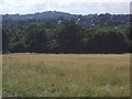
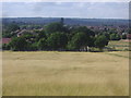
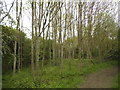
Harrow on the Hill from Fryent Country Park
Image: © David Howard
Taken: 24 Jul 2013
0.06 miles
3
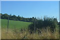
View across Kenton from Fryent Country Park
Image: © David Howard
Taken: 24 Jul 2013
0.06 miles
4
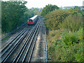
Southbound Jubilee Line train
It is approaching the curve taking the line around to a junction with the main Metropolitan Line. This section was initially a branch of the Metropolitan Line and then the Bakerloo Line before the Jubilee Line came into being.
Image: © Robin Webster
Taken: 13 Oct 2012
0.07 miles
5
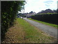
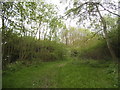
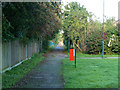
Path to Ledway Drive from Fryent Country Park
Image: © David Howard
Taken: 24 Jul 2013
0.07 miles
6
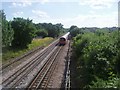
Train between Kingsbury and Wembley Park
Image: © David Howard
Taken: 24 Jul 2013
0.07 miles
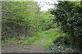
8
Footpath to The Mall
Leading from Fryent Country Park.
Image: © Robin Webster
Taken: 13 Oct 2012
0.08 miles