IMAGES TAKEN NEAR TO
Wilson Close, WEMBLEY, HA9 9SU
Introduction
This page details the photographs taken nearby to Wilson Close, HA9 9SU by members of the Geograph project.
The Geograph project started in 2005 with the aim of publishing, organising and preserving representative images for every square kilometre of Great Britain, Ireland and the Isle of Man.

There are currently over 7.5m images from over14,400 individuals and you can help contribute to the project by visiting https://www.geograph.org.uk
Image Map
Images are licensed for reuse under creativecommons.org/licenses/by-sa/2.0
Notes
- Clicking on the map will re-center to the selected point.
- The higher the marker number, the further away the image location is from the centre of the postcode.
Image Listing (61 Images Found)
Images are licensed for reuse under creativecommons.org/licenses/by-sa/2.0
Image
Details
Distance
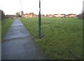
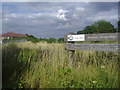
2
Footpath to The Mall
Leading from Fryent Country Park.
Image: © Robin Webster
Taken: 13 Oct 2012
0.03 miles
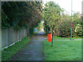
3
Path to Ledway Drive from Fryent Country Park
Image: © David Howard
Taken: 24 Jul 2013
0.05 miles
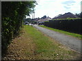
4
Fryent Country Park next to the Jubilee Line
Fryent Country Park has been kept to show how much of Middlesex looked before the suburban expansion of London in the 1920s and 1930s. There are 23 hay meadows and seven miles of hedgerows, four woods and 20 ponds.
The branch between Wembley Park and Stanmore was opened by the Metropolitan Railway in 1932. It was much harder to construct than anticipated and amongst the heavy works was the diversion of the Wealdstone Brook. It became part of the Bakerloo Line in 1939 when that line was extended from Baker Street to Finchley Road, from there taking over the Metropolitan's old slow tracks to Wembley Park before the Bakerloo continued to Stanmore. In 1979 it became part of the Jubilee Line to Charing Cross, and in 1999 was linked to Stratford by the Jubilee Line Extension.
The houses in the distance are in Tookey Close, beyond a recreation ground.
Image: © Marathon
Taken: 1 Jul 2015
0.05 miles
5
Jubilee Line footbridge, Fryent Country Park
Image: © Jim Osley
Taken: 22 Jun 2014
0.06 miles
6
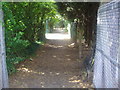
Path from Fryent Country Park to The Mall, Wembley Park
The railway is behind the fence between Wembley Park and Kingsbury, on the Jubilee Line.
Image: © David Howard
Taken: 24 Jul 2013
0.07 miles
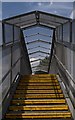
7

Steps down from the footbridge, Wembley Park
Crossing the Jubilee Line from Barn Hill
Image: © David Howard
Taken: 29 Apr 2014
0.07 miles
8
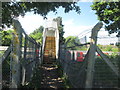
Footbridge over the railway northwest of Barn Hill
Image: © John Slater
Taken: 10 Jun 2017
0.07 miles
9
Railway Line between Fryent Country Park and The Mall
Image: © David Howard
Taken: 24 Jul 2013
0.07 miles
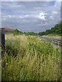
10
Kingsbury Nature Area by the Jubilee Line
Technically this is Wembley Park and the area is along the railway line cut off by high metal fences around, which are also extremely hard to take photos through.
Image: © David Howard
Taken: 24 Jul 2013
0.07 miles